Residensity
MHP's Center for Housing Data has launched Residensity, a new interactive web tool that recalibrates how we view housing density in Massachusetts. Available to everyone as of Feb. 16, 2023, Residensity features a user-friendly map platform that allows you to explore and analyze housing unit counts and residential density for any location in Massachusetts.
Check out Residensity: www.mhp.net/residensity
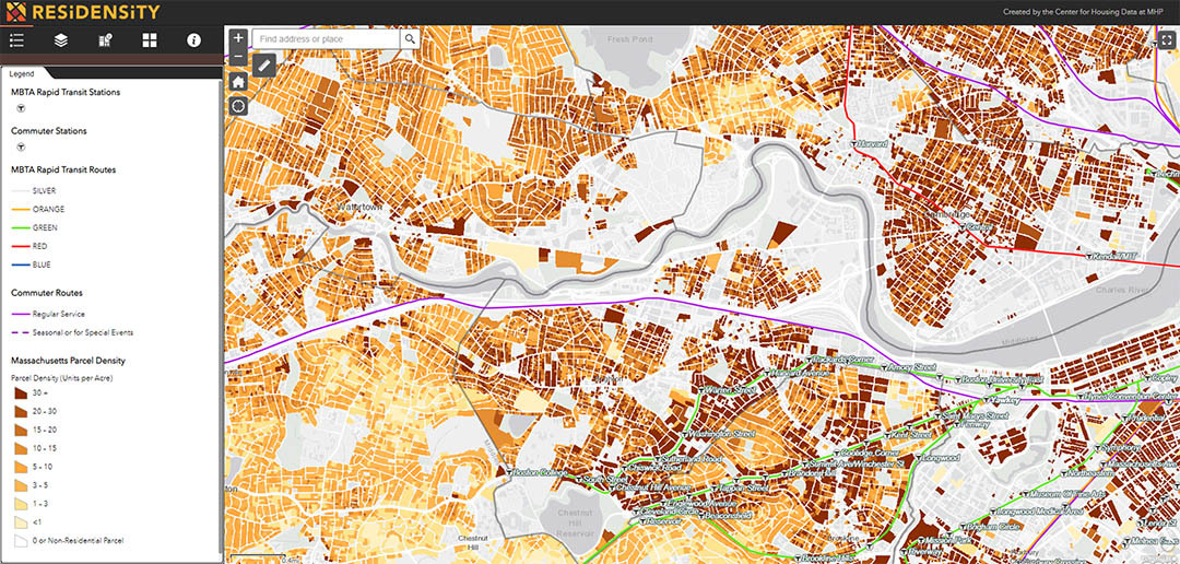
Residensity is built using a unique methodology developed by MHP's Center for Housing Data to estimate the number of homes at the parcel and lot level. This method employs multiple data sets to create a consistent, accurate, and comparable metric that can be used to compare housing patterns across municipal borders. Developed by MHP's Tom Hopper and Matija Janković, it represents a first for Massachusetts as nobody has calculated density across the state or built a methodology to keep the data up to date.
Residensity expands on methodology MHP developed to create Transit-Oriented Development Explorer (TODEX) in 2019, which estimates housing density around all Greater Boston's 261 transit stations. CHD also created and administers DataTown, which provides up-to-date housing and demographic information which can be downloaded as data or as data visuals.
All of these tools are meant to help policy makers, local leaders, volunteers and residents have more informed discussions about how to effectively address our housing needs.
Here are some of the reasons why Residensity will help us have better, more informed conversations about housing:
Residensity is for everyone
Residensity can be a helpful reference tool for any member of the public. Anyone who wants to learn more about their neighborhood or any neighborhood, or wants to compare one neighborhood to another, will be able to get quick and easy insights. We’ve had a ton of fun just panning around the map and getting a better sense of housing development patterns, and we think you will too.
There is also a professional use case for planners, developers, and others working in the housing and development fields. Residensity can provide a benchmark for existing housing conditions that can be compared to what’s allowed in zoning, for example, or to just take stock of what kinds of development a town already has.
We also hope that researchers and academics use our data set as an input to answer big policy questions, such as the relationship between residential density and socioeconomic diversity, or to conduct a proximity analysis, such as how many homes are within half a mile of a particular train station, or a proposed farmer’s market or grocery store.
Residensity is comphrehensive
We have analyzed over 2.16 million property records to create a unique, searchable database of housing counts and density in Massachusetts. Leveraging our unique methodology, our platform allows users to explore the housing density and land-use patterns of any community in Massachusetts with density calculations at the parcel level (note: parcels are the divisions of land on which a piece of real estate sits). By using point-level data it allows us to deliver a highly customizable and detailed tool to our users.
Residensity is interactive
With our platform, users can explore an interactive map of density and land use patterns of the whole state of Massachusetts. Our platform includes interactive data tools that allow users to calculate density statistics and land-use breakdowns of user-defined areas.
Residensity gives you immediate insights
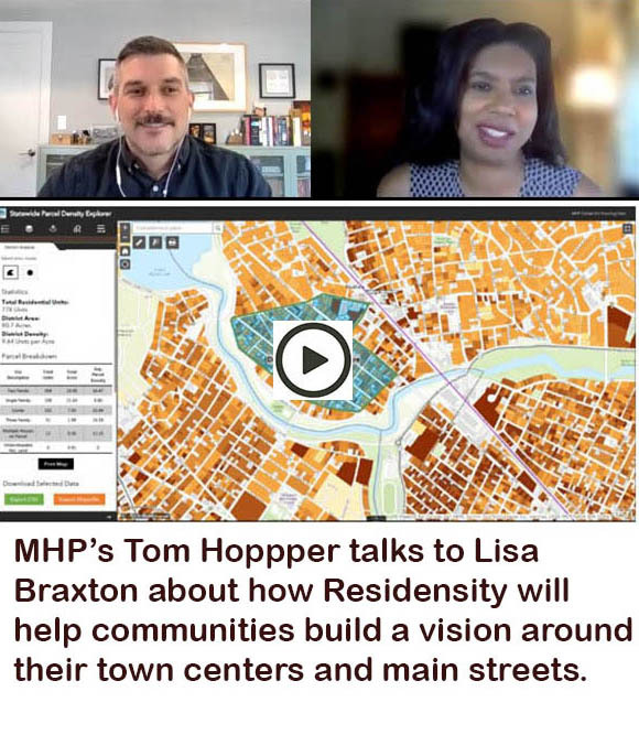
Users can draw unique districts and receive stats and breakdowns on the fly, explore density patterns around transit station areas, export PDF density maps with land-use breakdowns, and export data tables of parcels with density statistics for individual analysis.
Residensity's data is kept up to date
The platform is based on our methodology that estimates the number of residential units on each tax parcel in Massachusetts and calculates density (residential units per acre) for each parcel in the state. We refresh our public data set several times a year to ensure we are using the most recent source information.
Residensity is free to use & shareable
We built Residensity as a resource for anyone curious about housing density in Massachusetts. We are committed to collaborating with other researchers, and making our comprehensive data set available to others working on improving housing outcomes. Reach out to us if you’d like to make use of our data set or if there is a project or use case for Residensity you’d like to explore.
Residensity is responsive to users
You know your neighborhood, and we know our data sources and methodology occasionally miss something. We have integrated a process for collecting and verifying user-reported corrections to our housing counts, property uses, and residential density estimates. You can report a data correction or take our user feedback survey. With your help in reporting any inaccuracies, we can refine our methodology and build an even better resource over time.
Questions?
Contact Matija Janković at mjankovic@mhp.net or Tom Hopper at thopper@mhp.net.
More on Residensity
MHP's Hopper: New tool will help show how density shapes great neighborhoods
Rappaport Fellow uses Residensity data base to show equity & residential patterns