Created by MHP's Center for Housing Data in partnership with Way Finders
Posted on June 6, 2025
By Ellen Marya at MHP’s Center for Housing Data
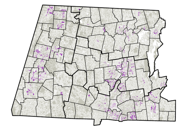
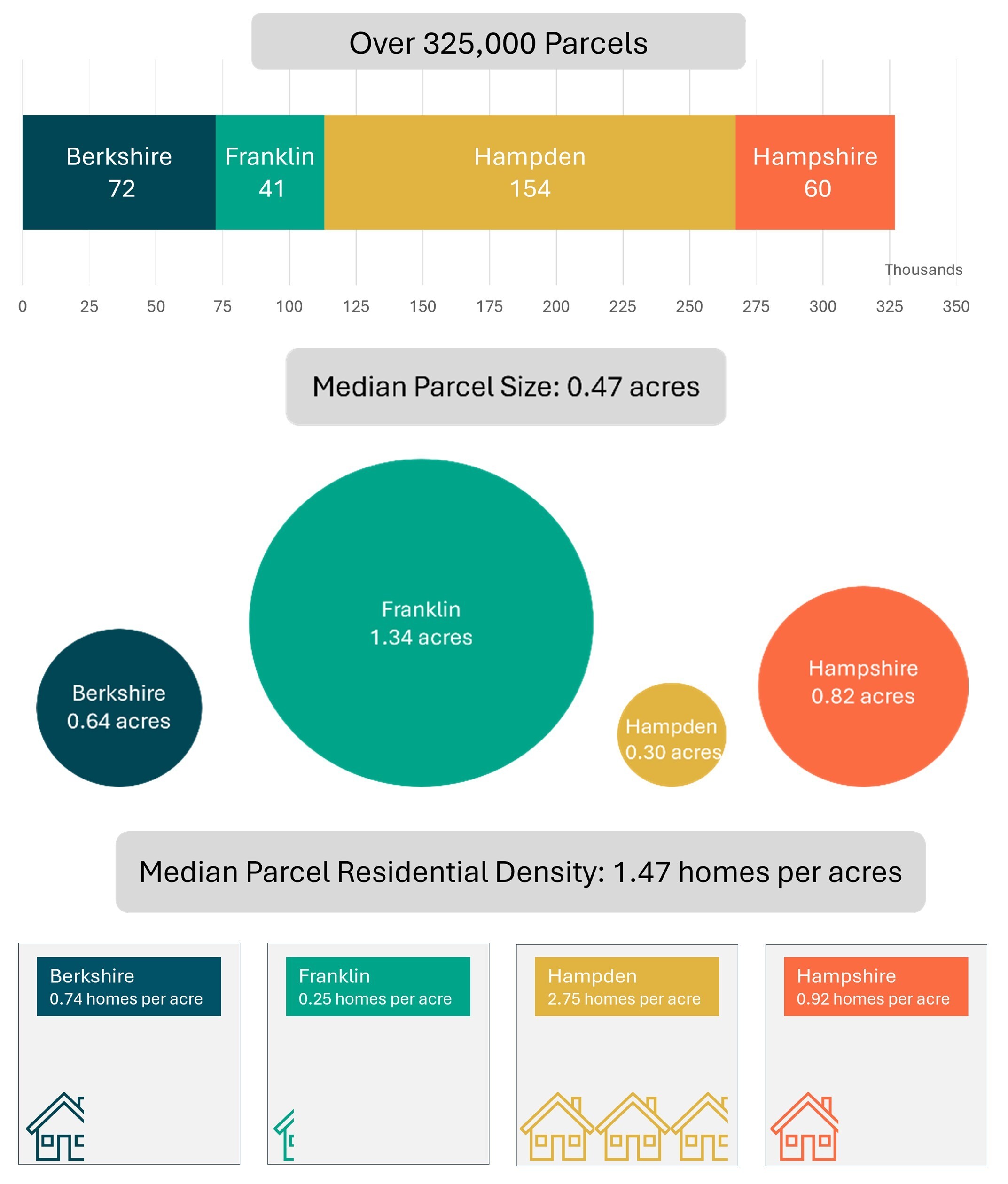
Western Massachusetts faces many of the housing supply and affordability challenges plaguing the Commonwealth as a whole within a unique regional context. The area’s four counties – Berkshire, Franklin, Hampden, and Hampshire – are home to over 800,000 people spread across some of the most rural and least dense areas of Massachusetts as well as in five Gateway Cities. The region has deep roots in agriculture, manufacturing, and education, and offers opportunities for urban, suburban, and rural living, along with second homes and vacation properties in destination communities. It is also home to dynamic and collaborative organizations that work in close partnership to develop housing solutions that fit the area’s needs, honor its historical resources, and mitigate the challenges to building affordable housing in this part of the Commonwealth.
Our collaborative effort between Massachusetts Housing Partnership’s Center for Housing Data (CHD), Way Finders, and the Western Massachusetts Housing Coalition launched in 2023 to analyze and better understand development potential in all parts of Berkshire, Franklin, Hampden, and Hampshire counties. The effort was sparked by emergent trends and needs across the region including: an increase in investor home purchases and speculation leading to attrition in affordability and increased housing instability for some residents; a desire for a proactive approach to affordable housing creation and anti-displacement efforts amid changing market conditions; and, a need for centralized and detailed data to better understand the challenges and opportunities of development from the granular level to the regional scale in order to identify the tools and resources needed to respond. The end-product of the work is a comprehensive, first-of-its-kind dataset including all parcels in the region with synthesized information about their suitability for development or redevelopment as housing. Way Finders will be able to leverage this data tool to advocate for policies and necessary resources that bolster housing development and promote housing affordability in western Massachusetts.
The purpose of this memo is to provide a summary of field work conducted in western Massachusetts, offer a methodological overview of our data-driven approach to exploring development opportunities, and present the results of four scenarios that use our novel database to identify and quantify certain types of development opportunities across the four counties in the region. Using the materials presented in this memo, the CHD team aims to collect feedback from stakeholders, collaborate with partners to test our database on additional development scenarios, and leverage these engagements to improve our approach and expand the geographic scope of the work. We anticipate Way Finders and partner agencies can also use this memo and its foundational dataset to augment their ability to identify potential development sites, expand and increase supportive programs, and promote policies and strategies that help address the counties’ housing challenges in line with community and regional visions.
Table of Contents
Stakeholder EngagementData Preparation Development Scenarios
- Scenario 1: Infill opportunities in neighborhoods with existing residential density
- Scenario 2: Accessory dwelling units near existing infrastructure
- Scenario 3: Proactive investments to preserve affordable housing
- Scenario 4: Diverse strategies and partnerships in Gateway Cities
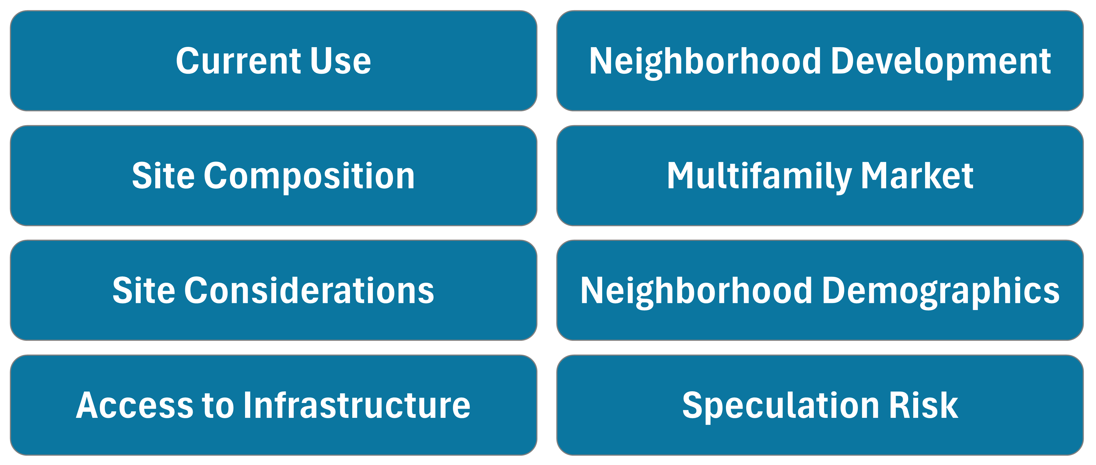
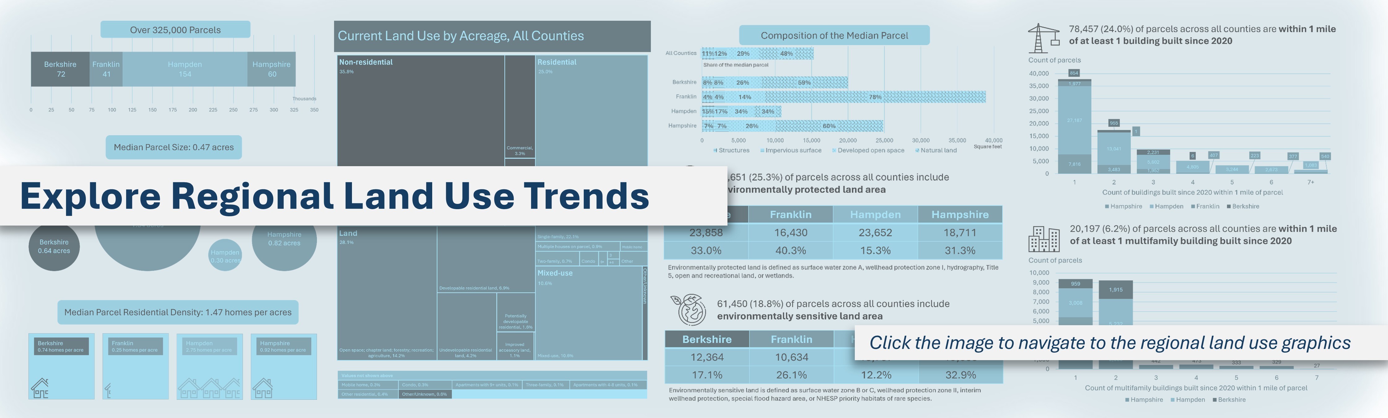
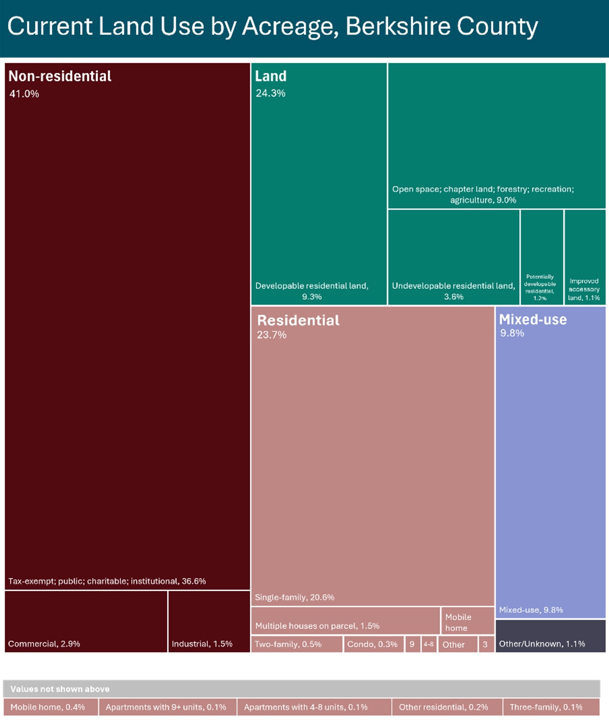
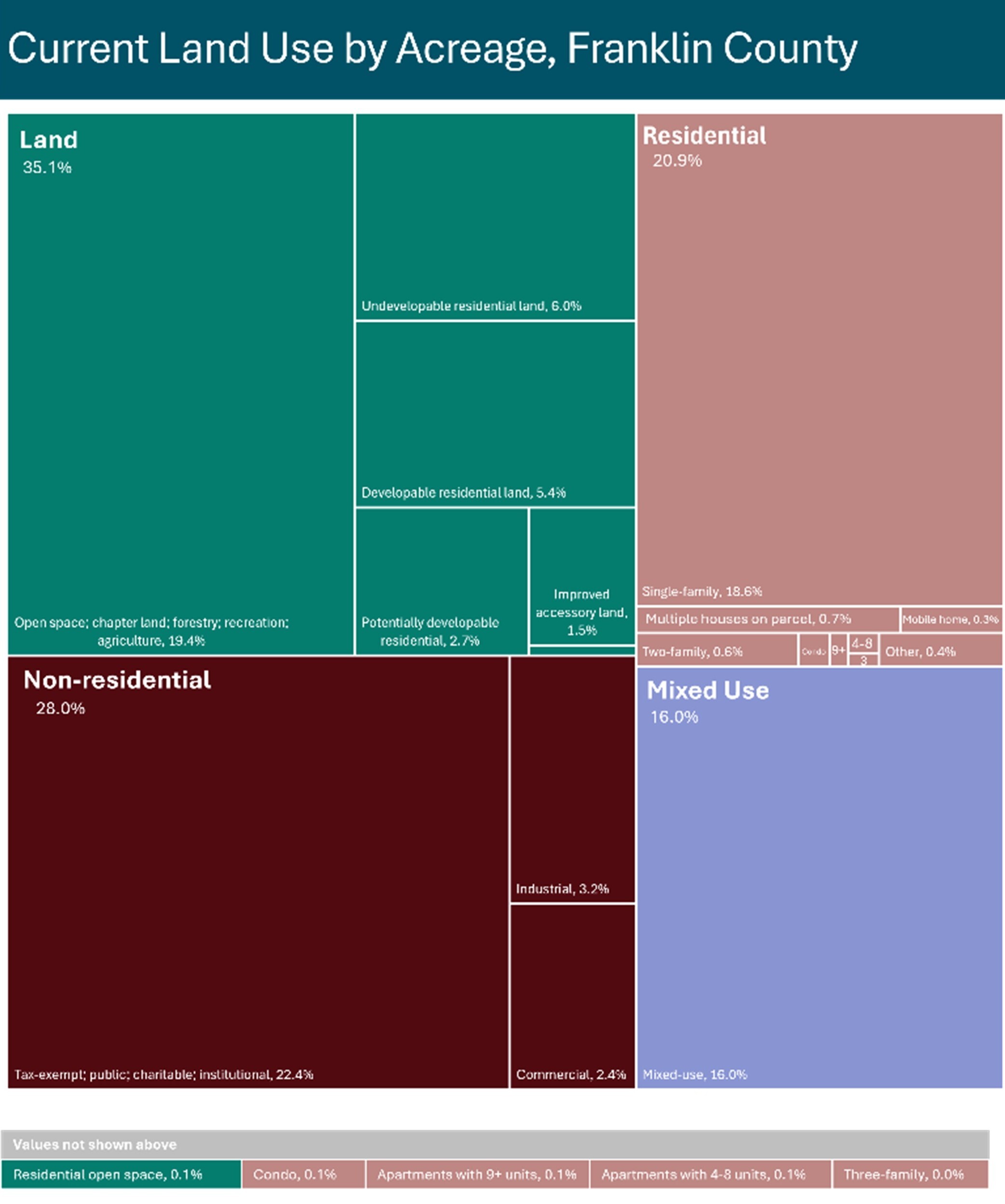
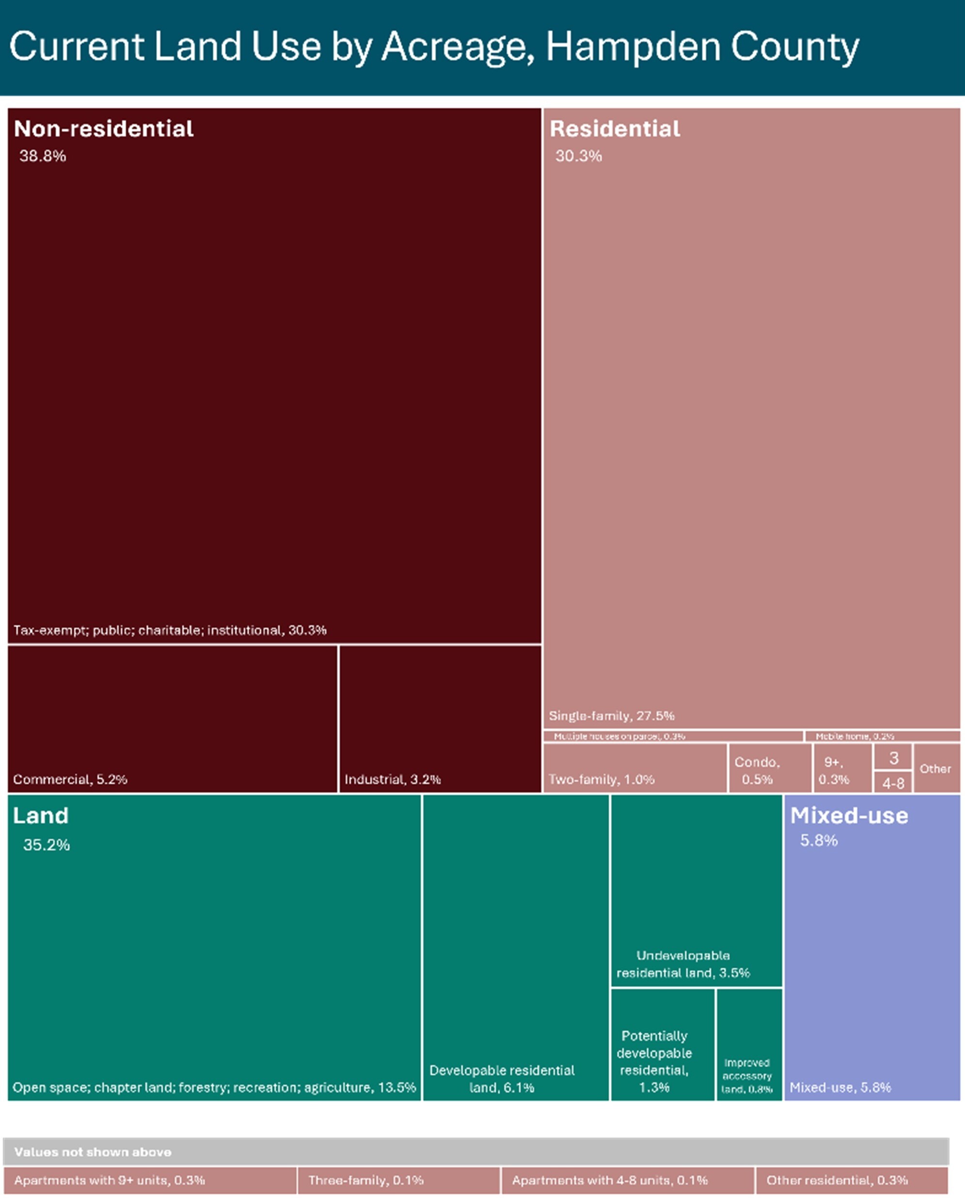
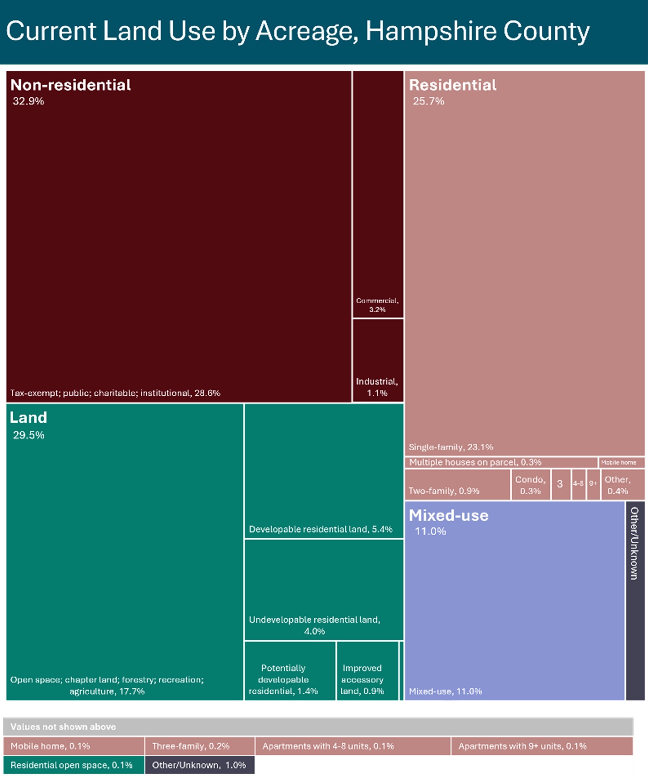
- Current Land Use
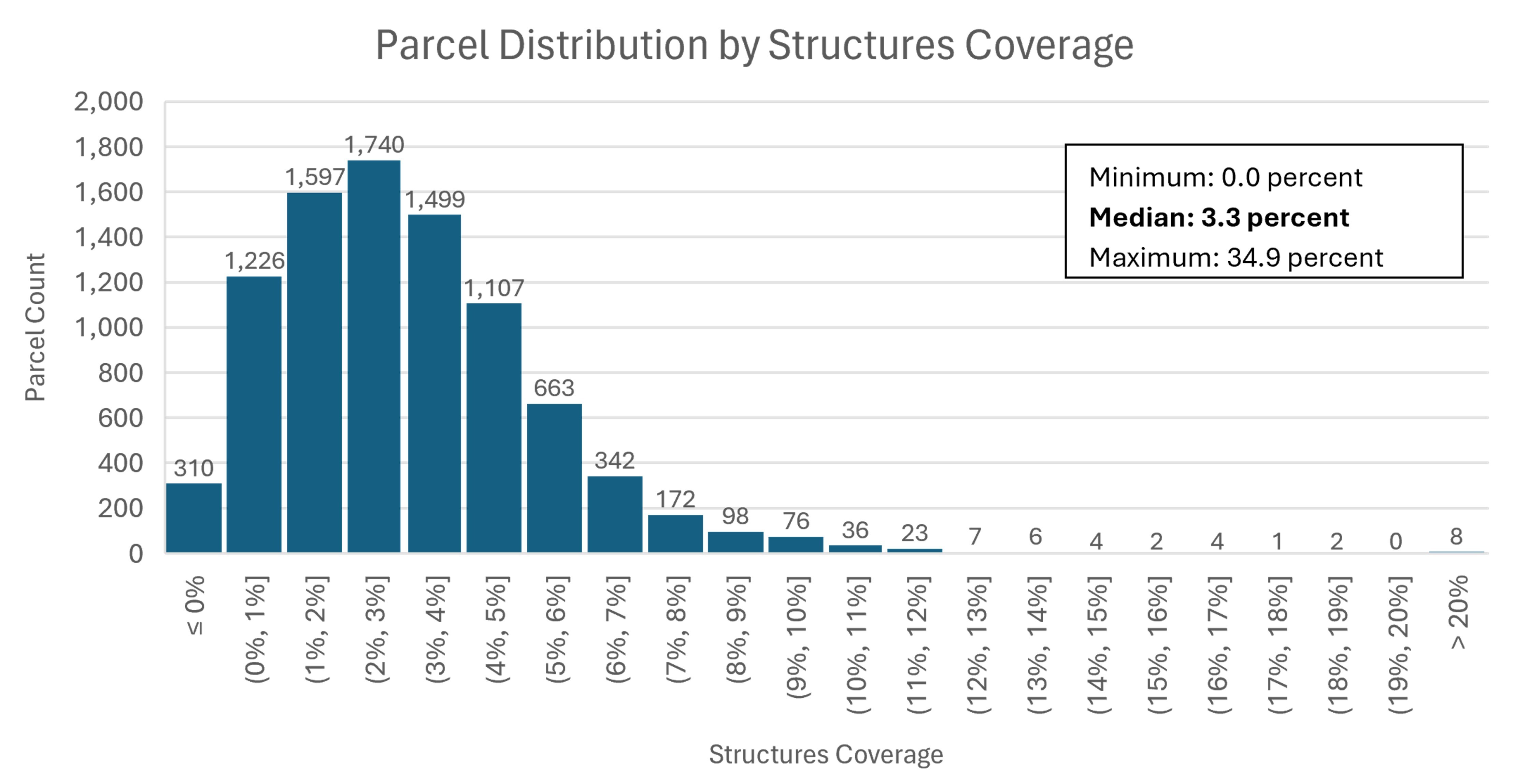
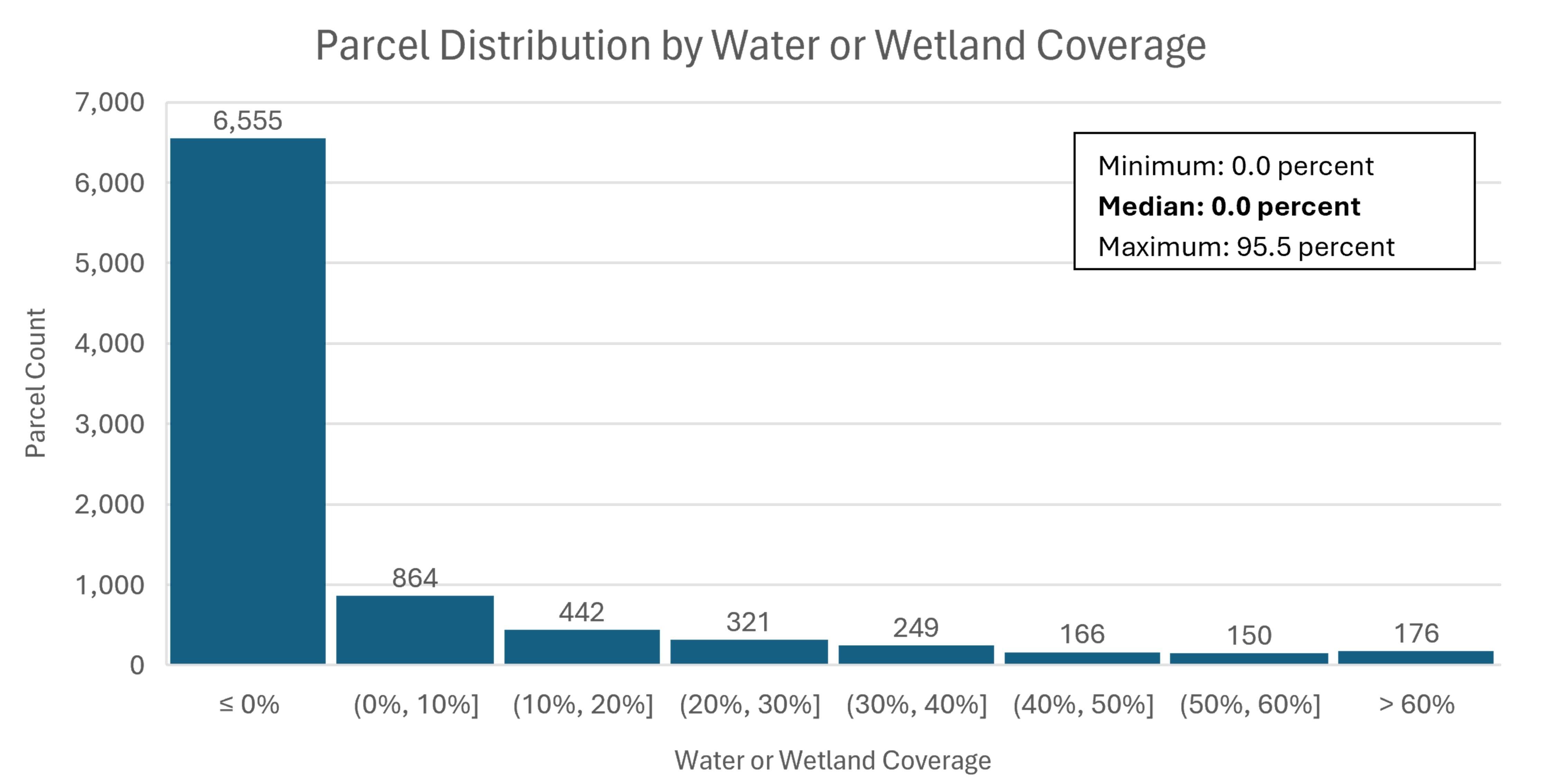
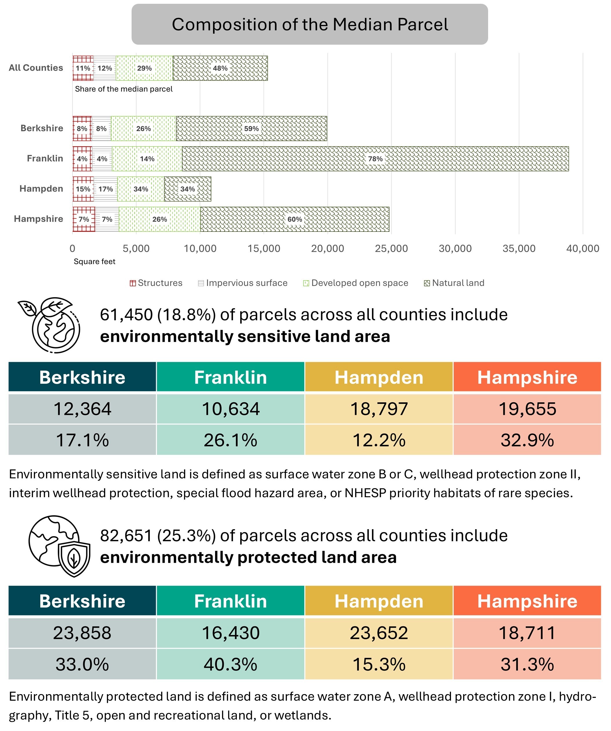
- Site Composition
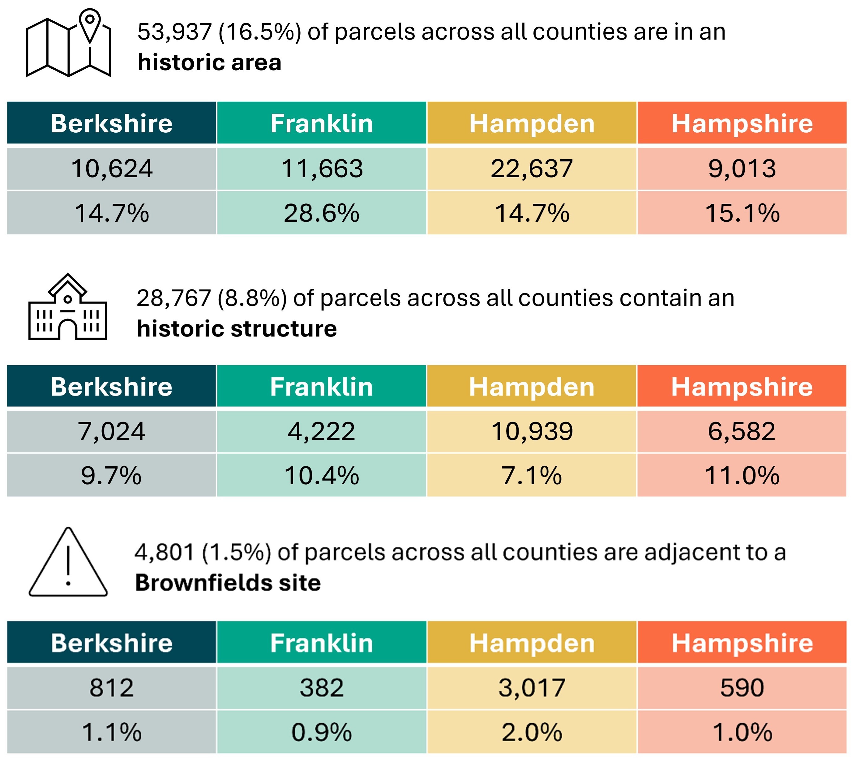
- Site Considerations
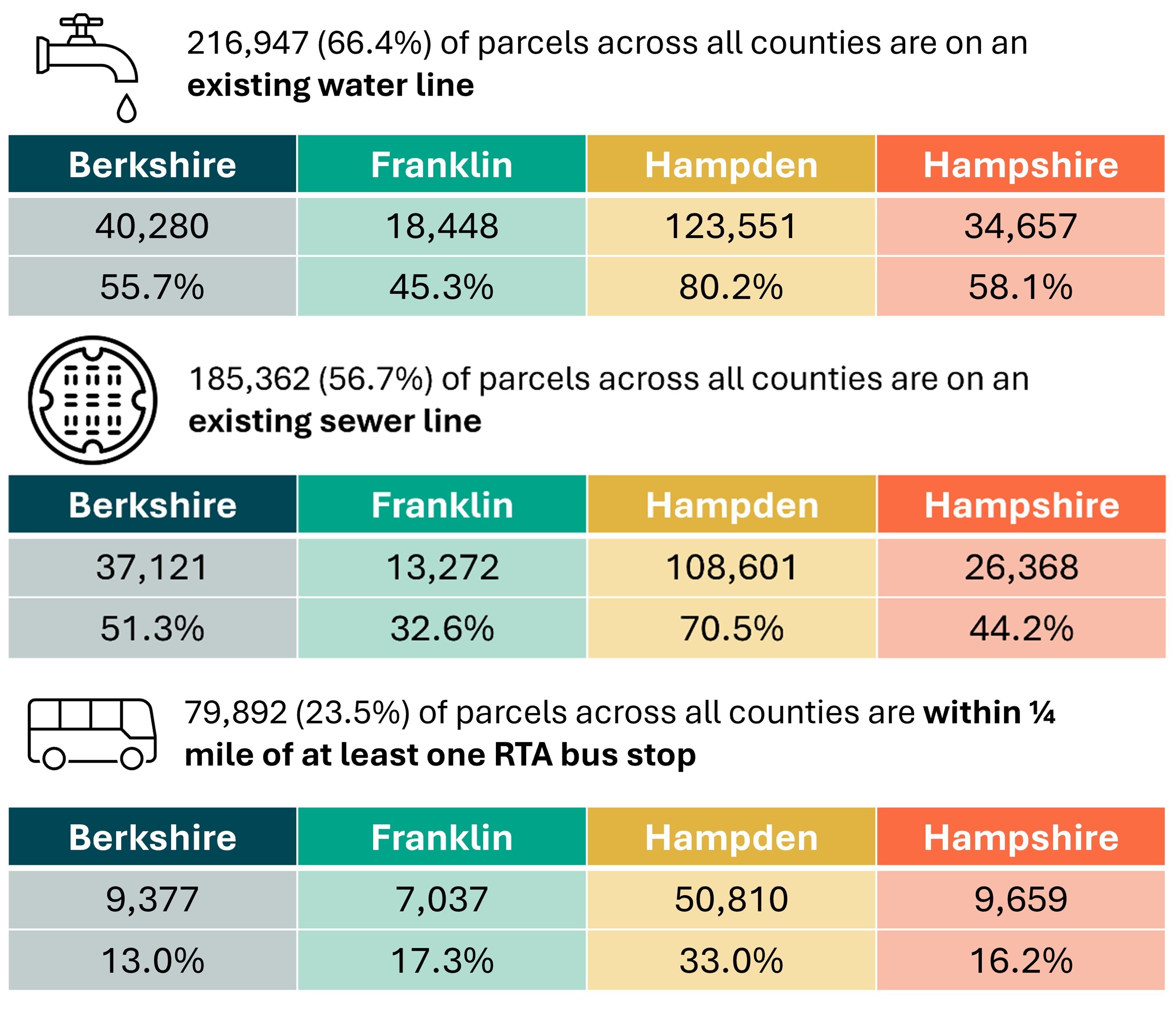
- Access to Infrastructure
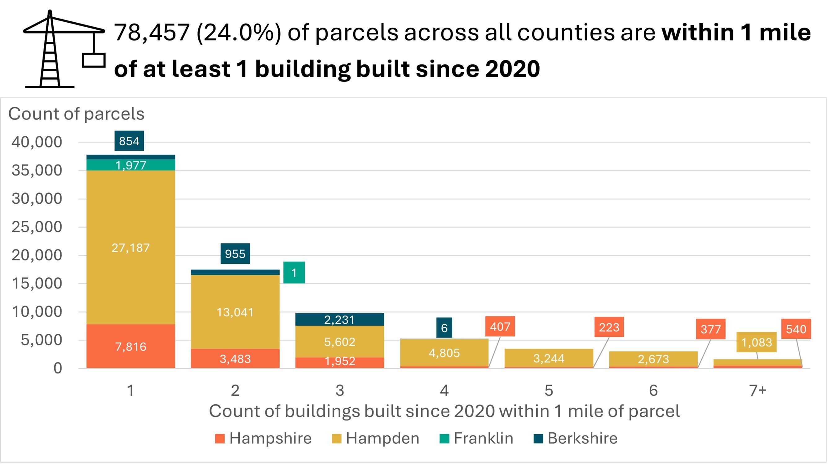
- Neighborhood Development
Appendix
Stakeholder Engagement
Our collaborative engagement began with field work to incorporate the extensive expertise of key stakeholders and partners working on the ground in western Massachusetts. The Way Finders team connected the CHD team to local and regional meetings and organized a full-day tour of sites and properties that exemplify the types of opportunities partners might seek to identify through this data tool. At these sites in Easthampton, Holyoke, Southampton, and South Hadley, the CHD team met with local officials and volunteers involved in positioning these parcels for housing development and held a discussion at the Holyoke site with MassHousing on collaborative efforts among MassHousing, MassDevelopment, Way Finders, the City of Holyoke, and other key stakeholders in the city’s High Street area. Throughout the project CHD also gave research presentations, facilitated focus groups and feedback sessions, and held conversations with the Western Massachusetts Housing Coalition, Berkshire Regional Planning Commission, Franklin County Regional Housing and Redevelopment Authority, Franklin Regional Council of Governments, and Pioneer Valley Planning Commission. These conversations informed all subsequent work on this project by uplifting common and specific themes on qualities that make sites attractive or challenging for potential development, context related to speculative investment in existing rental developments, regional planning priorities, and data considerations that CHD incorporated when building the database and crafting development scenarios explored in this memo. CHD prepared a field work report as part of this engagement, included here as Appendix A.
Data Sources
To create a database that captures and presents synthesized parcel data for the entirety of western Massachusetts, CHD began with our own Residensity database – a dataset including all parcels in Massachusetts, over 2.1 million records in total. CHD built Residensity in 2023, and continues to regularly update it, as a comprehensive resource for each parcel’s standardized size, current use, and residential density, along with key neighborhood- and community-level summary statistics. With Residensity as our foundation, we compiled numerous geographic data layers from MassGIS, the Commonwealth’s online collection of cleaned and processed data through the Bureau of Geographic Information. We supplemented this data with: additional publicly available information from the Massachusetts Department of Environmental Protection, the Massachusetts Department of Transportation, and the US Census Bureau; purchased data from CHD’s subscription to CoStar’s commercial real estate data platform; and, data provided by regional planning partners at the Berkshire Regional Planning Commission, Franklin Regional Council of Governments, and Pioneer Valley Planning Commission.
Data Processing
CHD conducted most data cleaning, processing, joining, and analysis work in ArcGIS Pro 3.2, Esri’s desktop geoprocessing software, with additional work in RStudio and Microsoft Excel. While each data layer was cleaned and processed based on its unique structure and characteristics, generally data were reorganized and/or summarized as needed to create one record within each dataset for each unique parcel identifier (LOC_ID) assigned based on the Commonwealth’s digital parcel standard. Depending on the dataset, this process included matching and joining new data to Residensity based on existing LOC_ID variables, geocoding data with alternative location information and running a spatial join process to correctly map this data onto parcels, and extrapolating summary information at different geographic levels (such as Census tracts or ZIP codes) to each parcel overlapping that area.
Data Limitations and Considerations
The full collection of variables included in the database is summarized in the following section and detailed in selected summary statistics. This represents a comprehensive collection and synthesis of key information for understanding development potential and speculation risk in western Massachusetts. There are, however, limitations to this data and important considerations for database users and memo readers.
First, certain data key to informing judgments about parcel suitability are not available on a wide geographic scale. CHD determined that some of this data provided significant enough coverage to be included in the database while acknowledging its incompleteness, namely CoStar data on large multifamily buildings and markets. Close attention should therefore be paid to which data points are available for geographies of interest. Second, all included data represent a point-in-time snapshot. CHD endeavored to include the most recently updated version of each contributing dataset, resulting in data from varying time periods for different underlying sources. Some of the data, including water and sewer infrastructure, are over a decade old but was deemed valuable enough to include even without more recent updates. The vintage of each source dataset is included in the data dictionary in Appendix B. Finally, we recognize some data crucial to understanding development potential is not included here, underscoring the importance of using the database as a starting point for assessing suitability and not as a replacement for due diligence and more nuanced site analysis. Notably, zoning data is not yet available at a comprehensive geographic scale, and users should confirm zoning on parcels of interest from other sources.
Final Variables
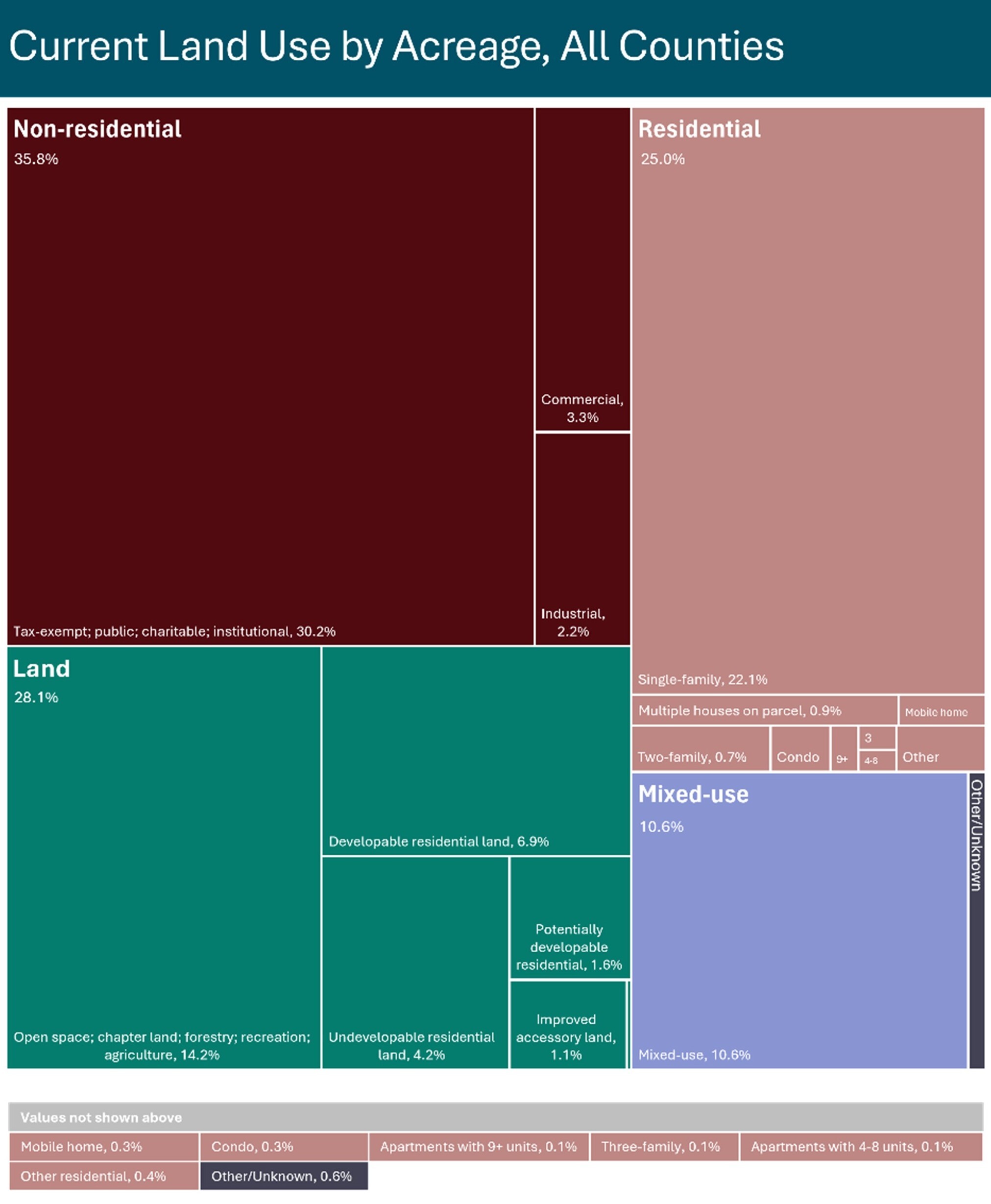
The final dataset includes nearly 100 variables grouped by the following themes:
While not every variable is available for every parcel due to limited availability, analyzing these thematic categories at the summary level offers insight into the potential scale and type of development opportunities across the region as a whole.
Development Scenarios
In addition to summarizing overall characteristics of western Massachusetts parcels, we can use this database to find potential development sites that fit criteria we choose based on a project type of interest. We start with a general project type reflecting a recent development, policy, or strategy identified during our stakeholder engagement process, provide a local example, and work through the process of applying various data conditions to filter our results to a manageable group for further due diligence. The following four project typologies demonstrate how we can use the data to identify an initial set of sites to explore that fit regional and community housing priorities.
Scenario 1: Infill opportunities in neighborhoods with existing residential density
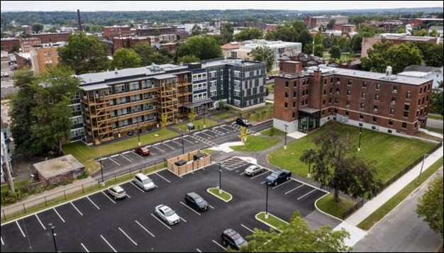
Project Typology: Adding housing in areas of high existing residential density offers the opportunity to increase housing options within established neighborhoods. Such infill development can take the form of new construction on vacant land or redevelopment of existing structures that are preserved and reimagined, or demolished and rebuilt. One recent example of this type of development is Way Finders’ Library Commons project, a combination of three rehabilitated historic buildings and one new construction building providing 38 two- and three-bedroom homes plus supportive services. This development is located in a dense area of Holyoke comprised of larger apartment and condo buildings, single-family and small multifamily buildings, and industrial and commercial structures – along with parks and other community resources.
Analysis: To identify parcels that might accommodate this type of infill development, we looked for underutilized sites with the potential for residential redevelopment. Western Massachusetts has a long history as a manufacturing and light industrial hub, though much of this economic activity has shifted over time. Given these changes, many urban residential neighborhoods have older mills, warehouses, or other commercial or industrial buildings no longer being used to their full potential. To find these possible opportunities, we searched for parcels with a current commercial or industrial use and an assessed value under $100,000 (the 25th percentile of assessed values for commercial and industrial properties). This low assessed value gave us an indication that the site may no longer be operating as a thriving business. We also only included sites with a census tract level residential density over four homes per acre (the 75th percentile of density levels). This higher level of residential density ensured we would look within existing neighborhoods more likely to support desirable housing than underutilized sites disconnected from the community fabric.
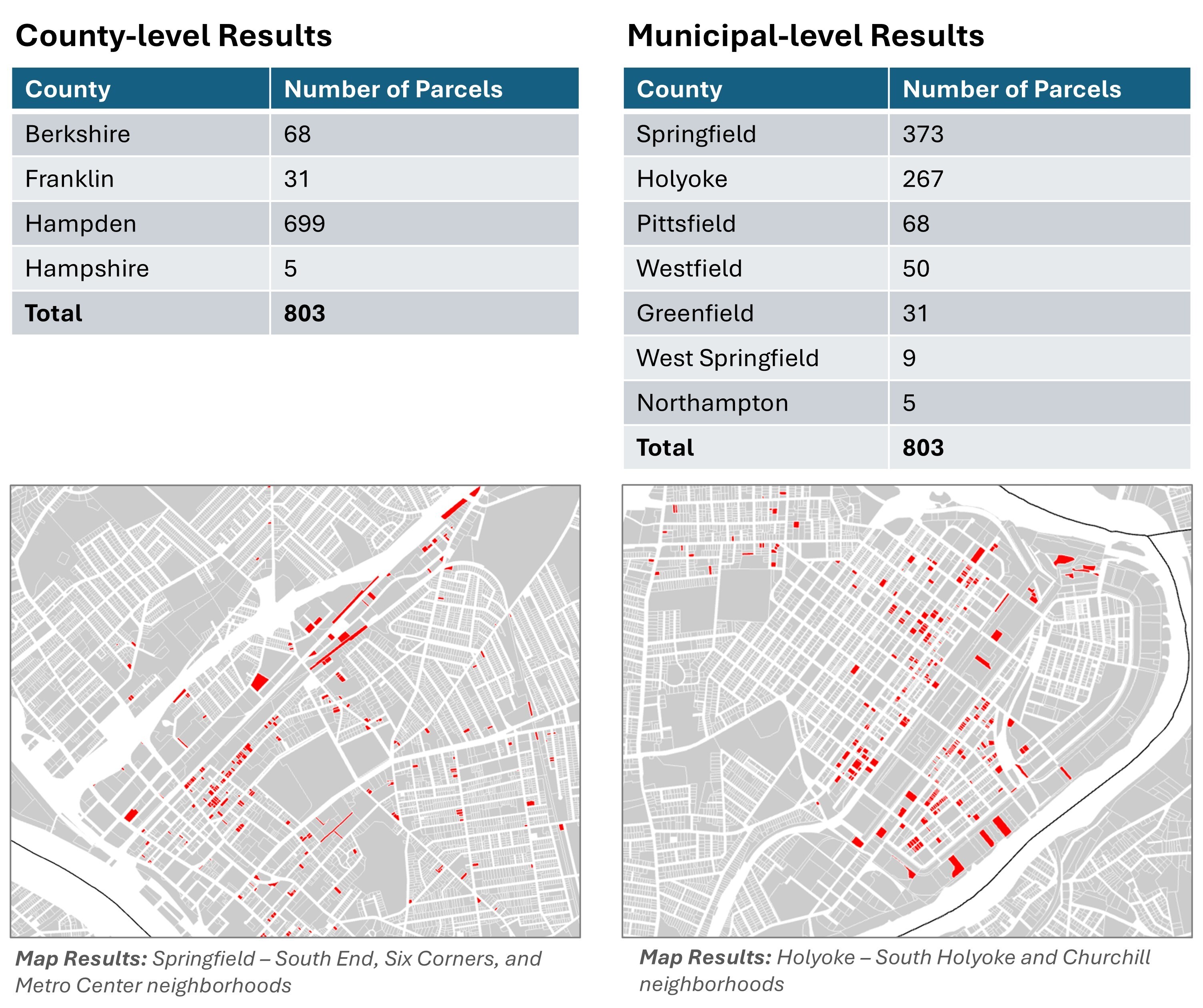
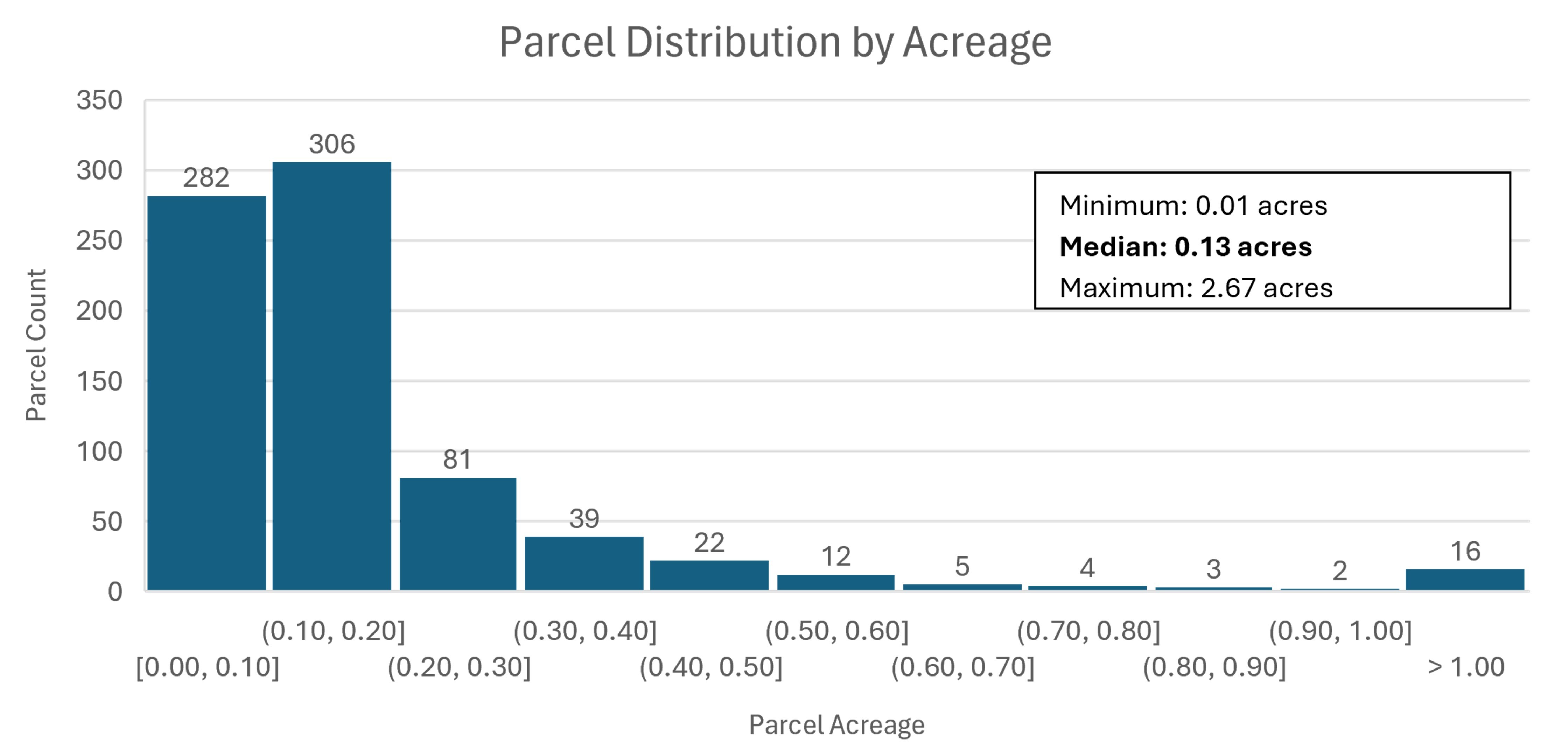
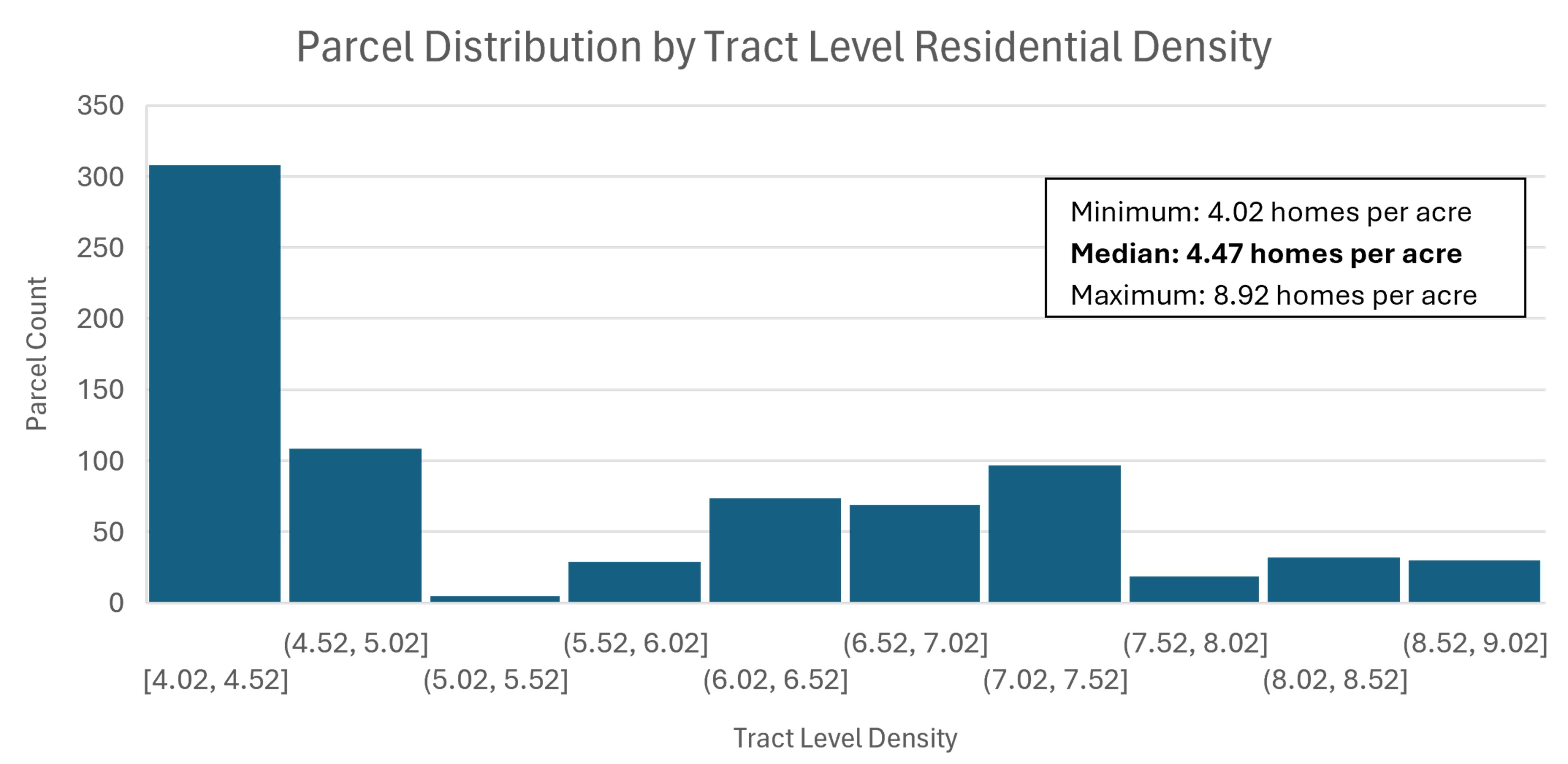
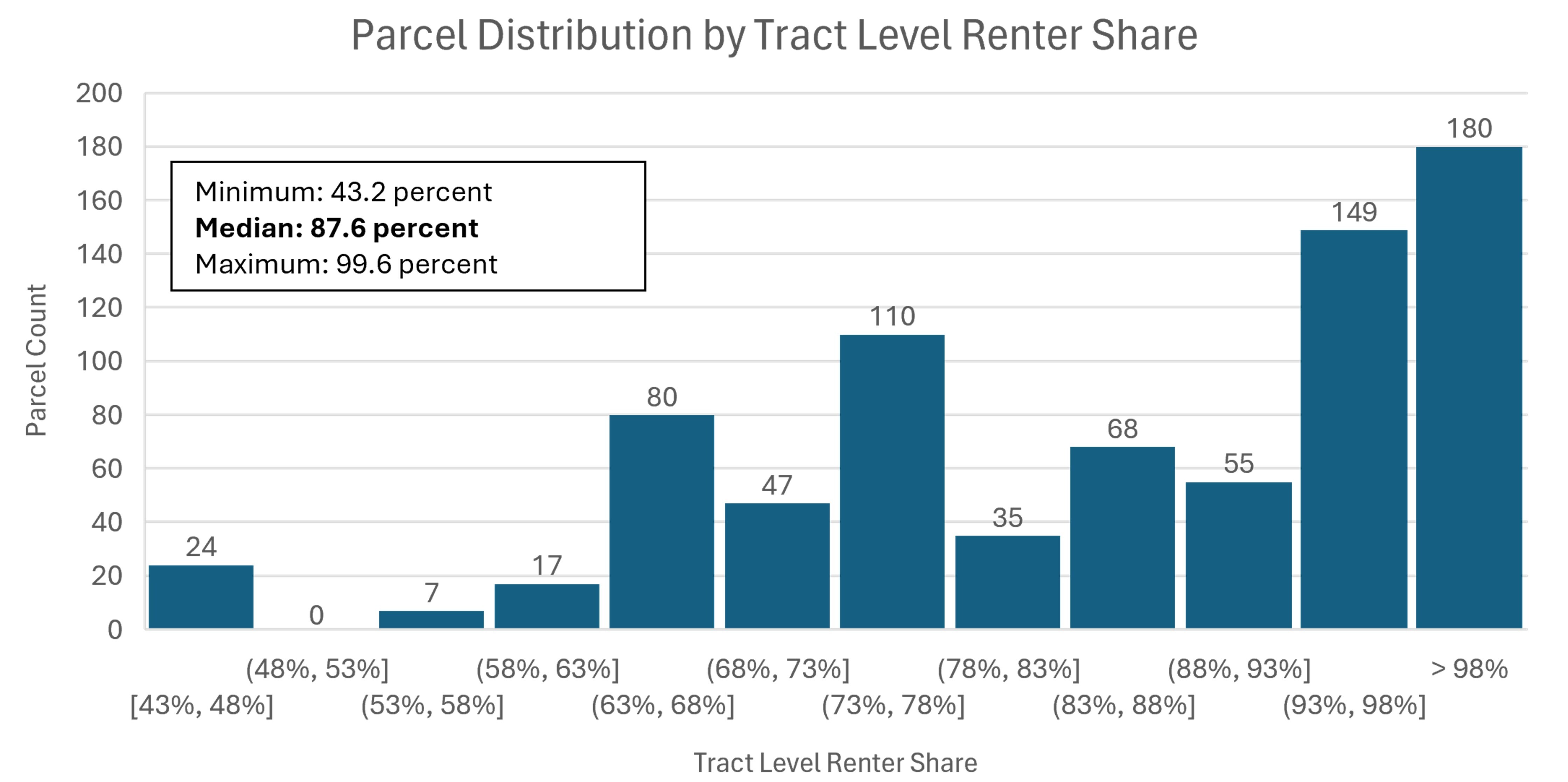
Results: This analysis yields 803 parcels, primarily in Hampden County and largely concentrated in the cities of Springfield and Holyoke, reflecting higher residential density levels in these areas. The parcels are roughly evenly split between those with at least one existing structure (389) and those with no existing structures (414). Key characteristics of these 803 parcels are summarized below, showing that they are generally small, in modestly dense census tracts, and in relatively tight rental markets with low vacancy rates and high shares of renter households:
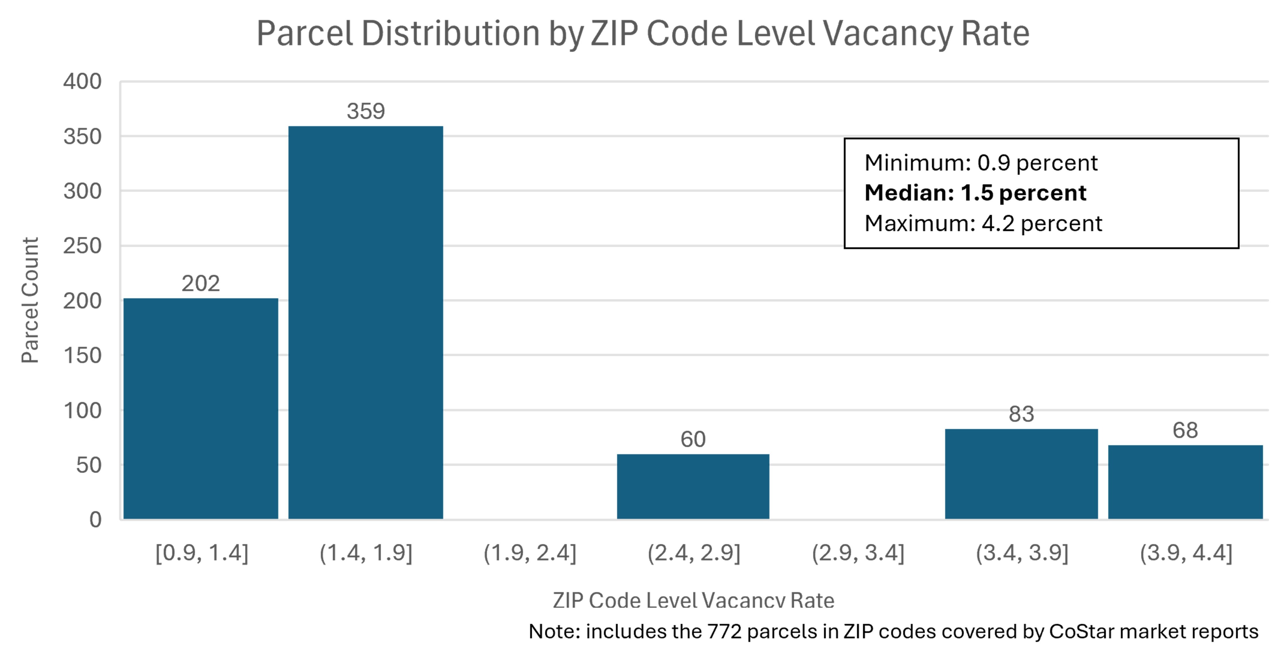
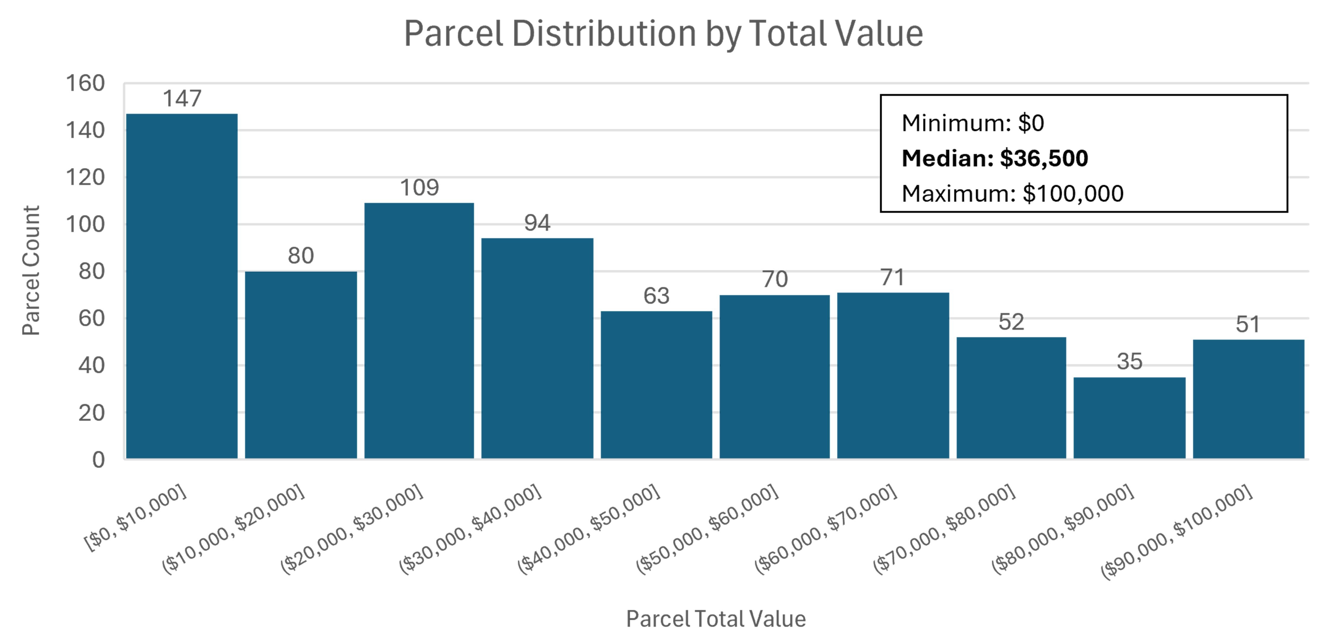
As we only searched for parcels with a total assessed value under $100,000, those values range from $0 to $100,000 with a median of $36,500.
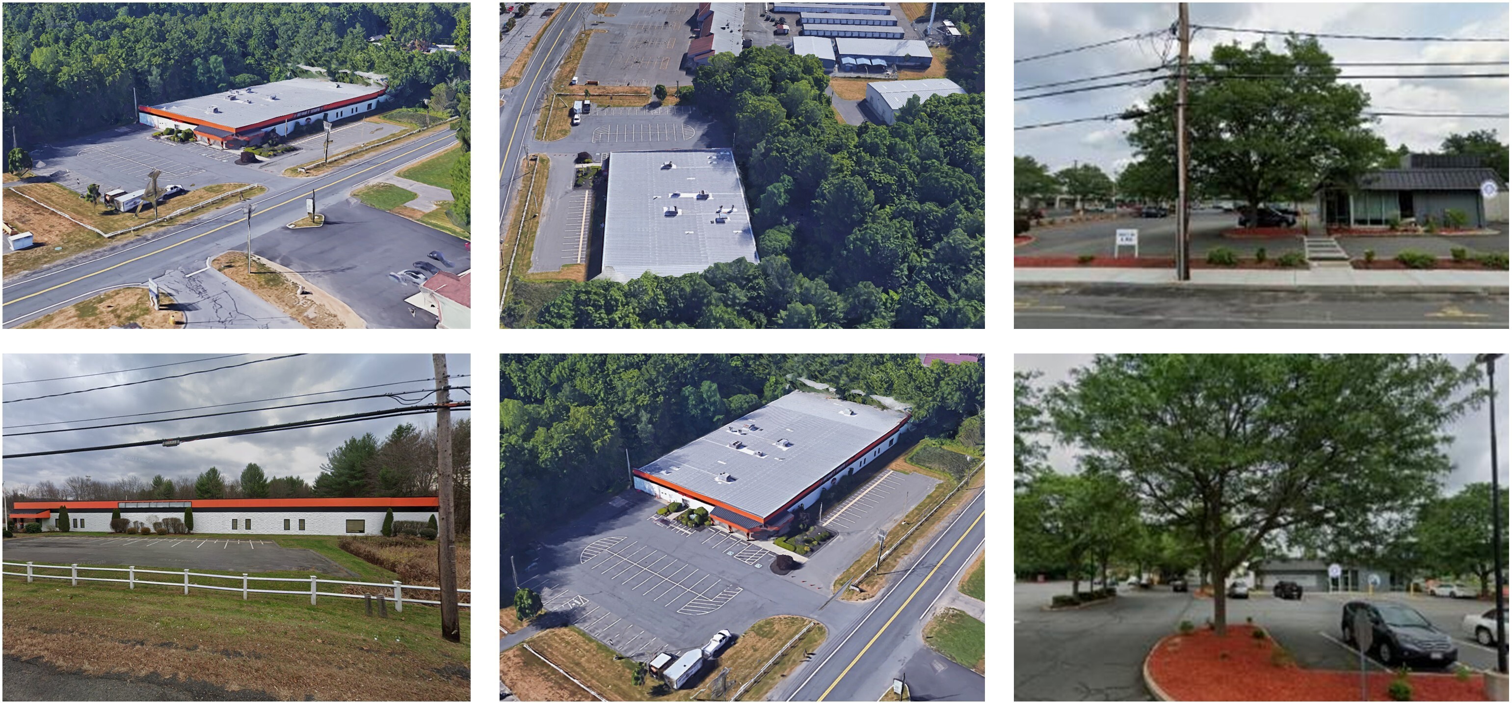
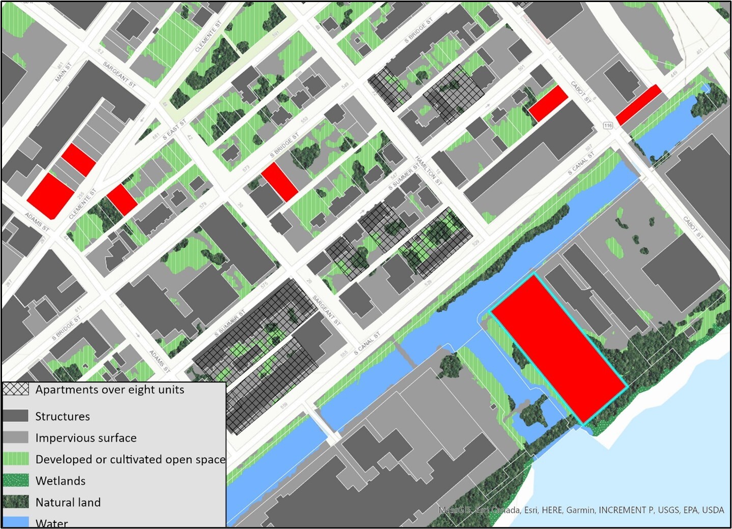
Deeper Dive: If we continue to refine this search, we can home in on potential opportunities. If we add additional filters that identify only the parcels of our 803 that have no existing structure —to avoid the need for demolition —we narrow our group to 414 parcels. If we explore the neighborhoods around these parcels, we can gain a better understanding of density levels and parcel sizes of nearby existing multifamily buildings. Multifamily buildings with eight or more units —a size that increases project feasibility— in these neighborhoods are typically on parcels of at least 0.10 acres and setting that as our minimum leaves us with 266 parcels. As we inspect these parcels, we find examples like the three shown below (red outlined in blue) in Springfield next to an existing multifamily building (gray crosshatched) that has 27 units.
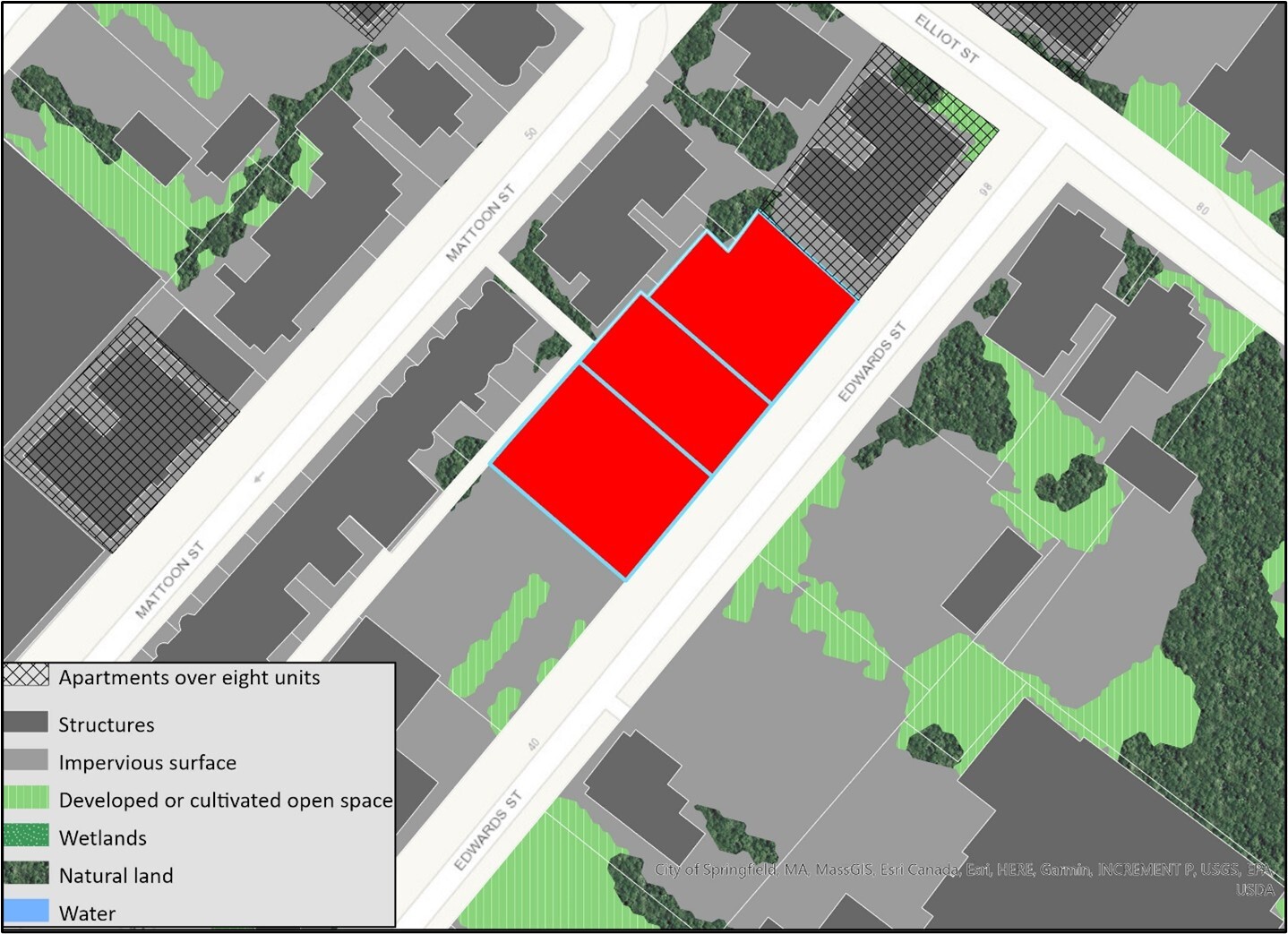
Our assembled data tells us that these three parcels are classified as commercial parking lots. They are 0.19 acres, 0.13 acres, and 0.16 acres and assessed at $84,500, $64,000 and $71,900. As they are located in a well-developed area, the parcels are along existing water and sewer lines. They are not listed as adjacent to brownfields sites, they fall within the Quadrangle-Mattoon Street Historic District, and all three have listed owners with the same address. They may provide parking for the neighboring apartments or other buildings in the area, but they are within ¼ mile of an RTA bus stop and could offer more parking than the neighborhood demands.
We can use the data tool to explore a second potential opportunity in Holyoke. The parcel shown below is 1.77 acres and classified in the assessors data as developable industrial land with a total value of $36,400. The site does contain both protected and sensitive land, including wetlands and priority habitat, and is located between the Connecticut River and the Third Level Canal. Nearly 52 percent of the parcel comprises natural land, another 17 percent is developed open space, and the remaining 31 percent is impervious surface. The parcel is also part of The Flats – South Holyoke historic area. Two new multifamily properties listed by CoStar have been built since 2020 within one mile of this property, and the opposite side of Canal Street houses several multifamily properties.
Summary: Commercial and industrial properties may present opportunities for redevelopment as multifamily housing. Our analysis shows there are hundreds of properties that are underutilized in urban areas such as Springfield, Holyoke, and Pittsfield. Such properties with low assessed values in areas of relatively higher residential density could be opportunities for infill redevelopment in neighborhoods with existing homes. The development of these parcels would not only serve to expand the housing supply but would also help to activate and stabilize these parcels, knitting them back into the fabric of the community. To fully explore the development potential on these parcels, additional investigation is needed of area zoning to understand the need for rezoning or site variances to allow for multifamily development. It is also critical to understand the neighborhood mix of residential and commercial or industrial uses and the details of a site’s current use and its utility to the community. Potentially hazardous previous uses, which may not always be listed as brownfields sites, and dilapidated conditions can pose costly barriers to redevelopment, while a low assessed value may not capture a site’s true high value to a community. These questions can be explored through further due diligence on a smaller pool of potential parcels the data has pointed us to.
Scenario 2: Accessory dwelling units near existing infrastructure
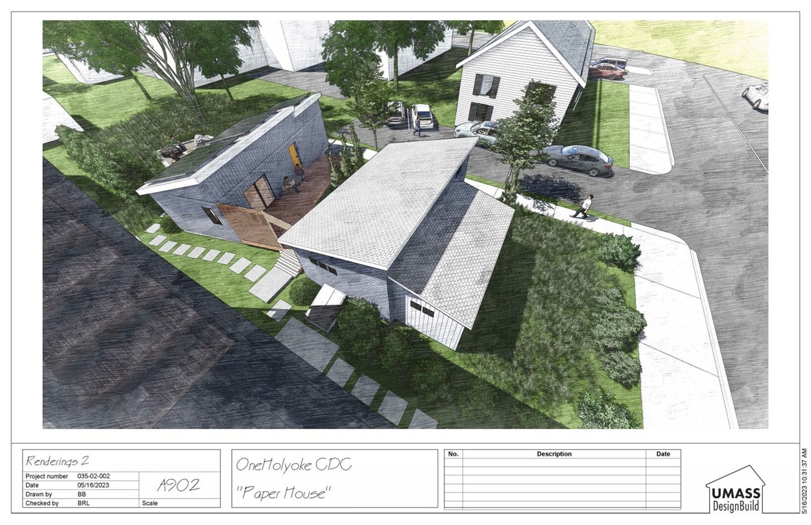
Project Typology: With the recent passage of the Affordable Homes Act in Massachusetts, Accessory Dwelling Units (ADUs) are now allowed by-right statewide in areas zoned for single-family homes. This legislative change simplifies the process of building homes on infill sites of all kinds – from denser urban areas to rural towns. Innovative groups such as the UMass DesignBuild Program have been exploring how ADUs can fit into the western Massachusetts housing landscape as statewide and local regulations are codified. In 2024 the program constructed the prototype Hygge House and Paper House in partnership with OneHolyoke Community Development Corporation using innovative modular off-site building techniques and net-zero ready sustainable designs. These types of collaborations and supportive legislative changes are significant, though numerous barriers remain to broader-scale ADU development.
Analysis: One crucial barrier to development is regulations that often require a fully upgraded septic system when adding an ADU to serve additional bedrooms on the property. Septic costs will vary depending on local regulations, site conditions, and the size and condition of an existing system, but are likely to run in the tens of thousands of dollars based on other states’ experience adding ADUs. Given that this cost can be prohibitively expensive for many homeowners and community-based developers, we sought to identify parcels located on existing sewer lines with a current single-family use. We initially included only parcels comprising at least one acre (though ADUs can certainly be built on smaller parcels) with less than half that acreage occupied by an existing structure.
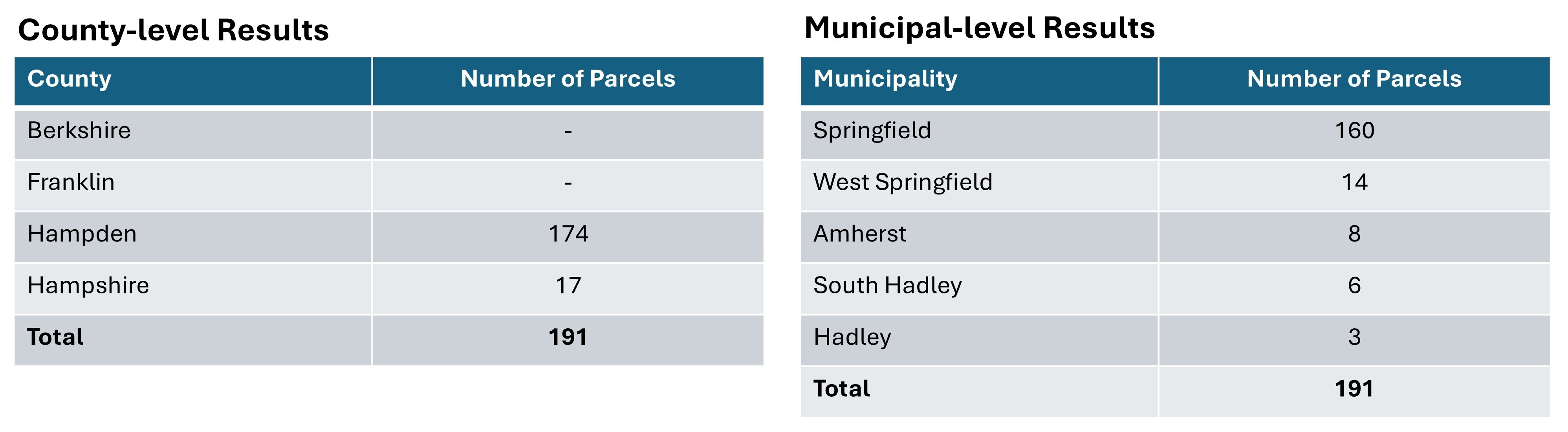
County-level Results
Municipal-level Results
Map Results
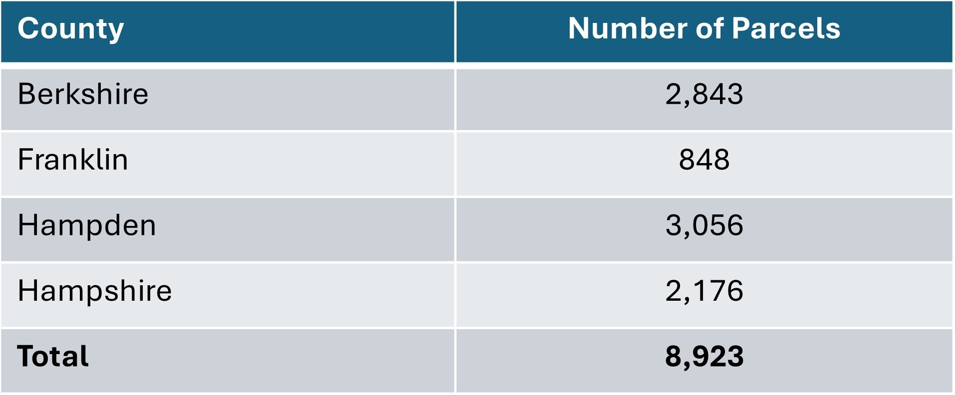
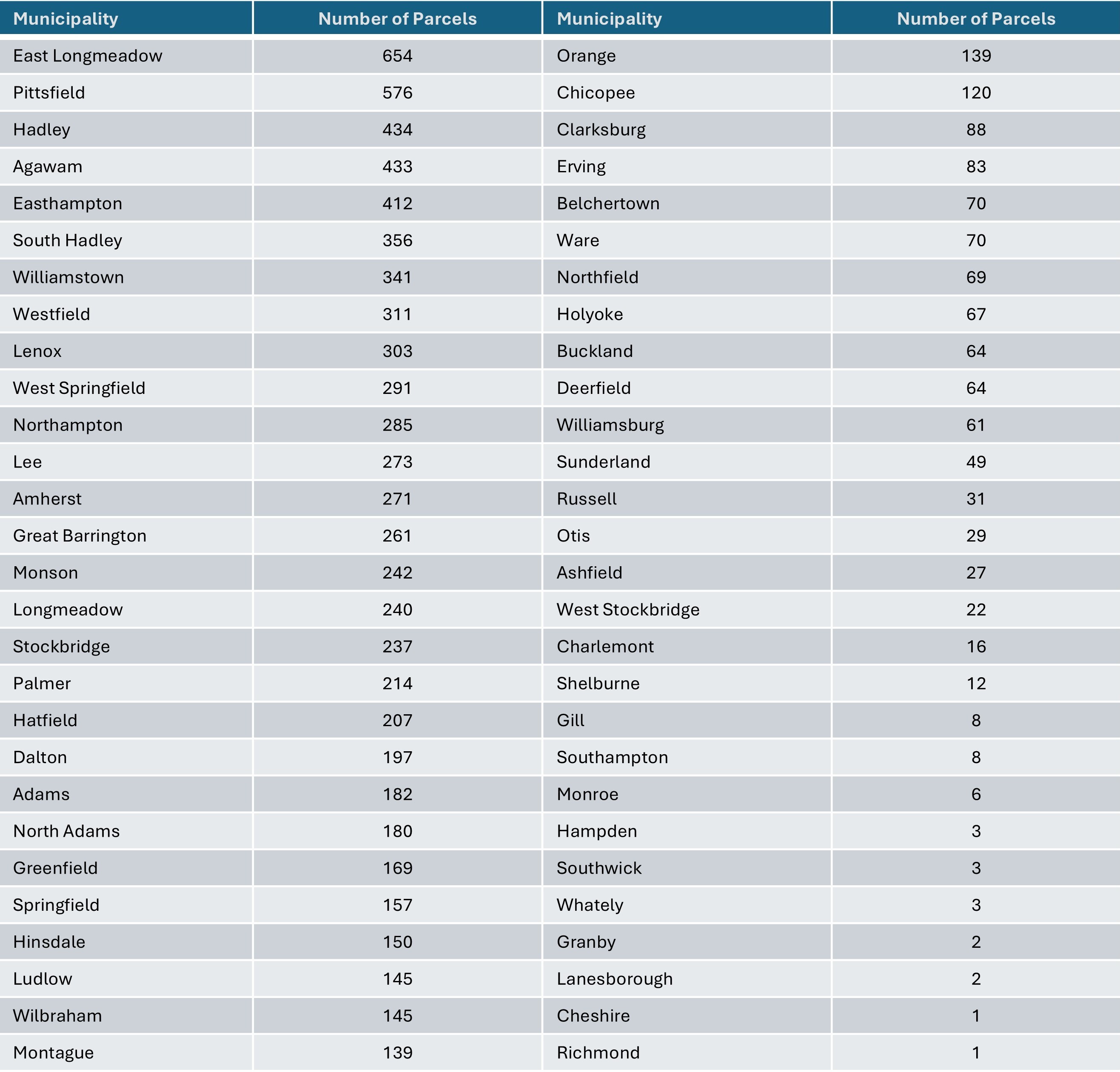
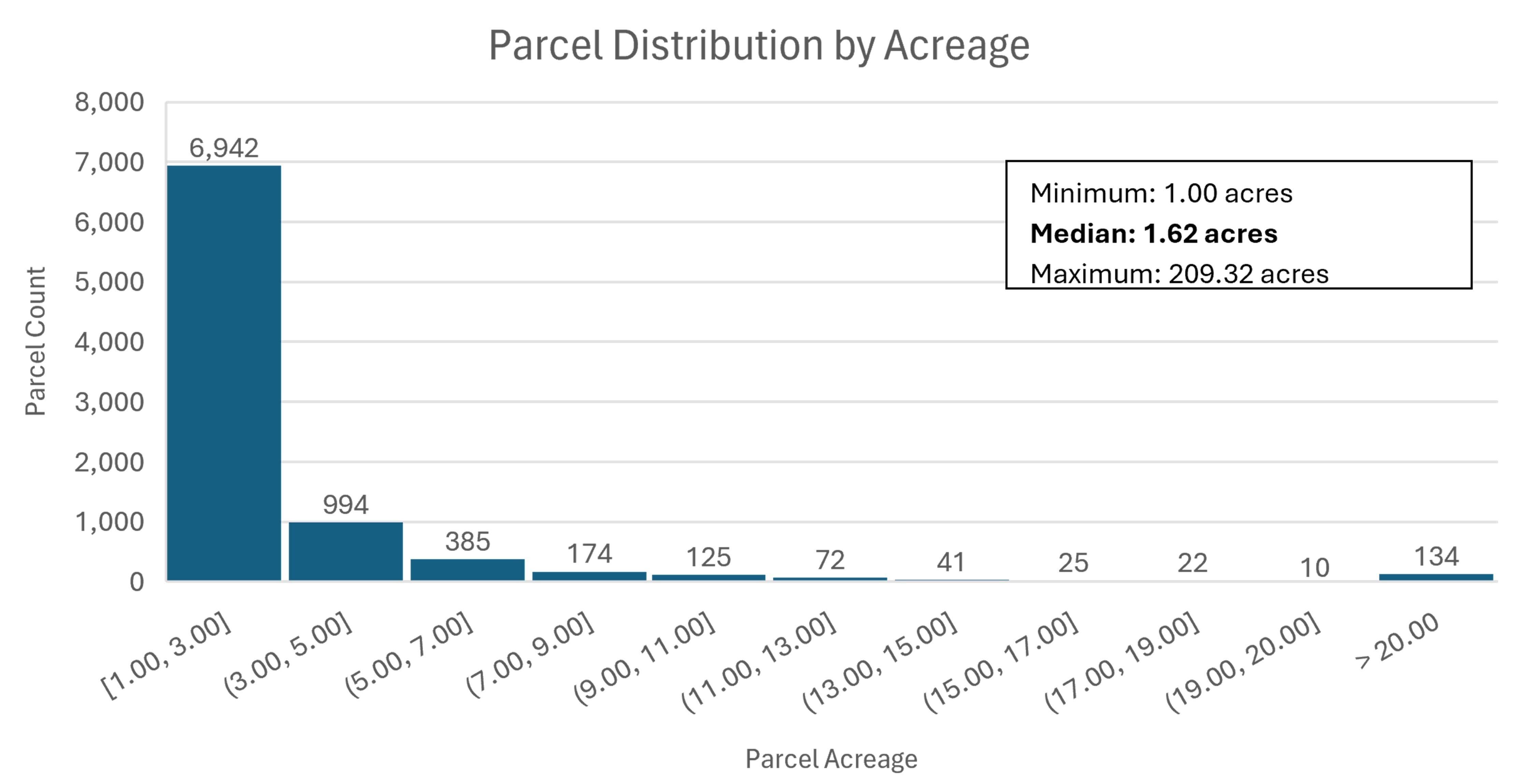
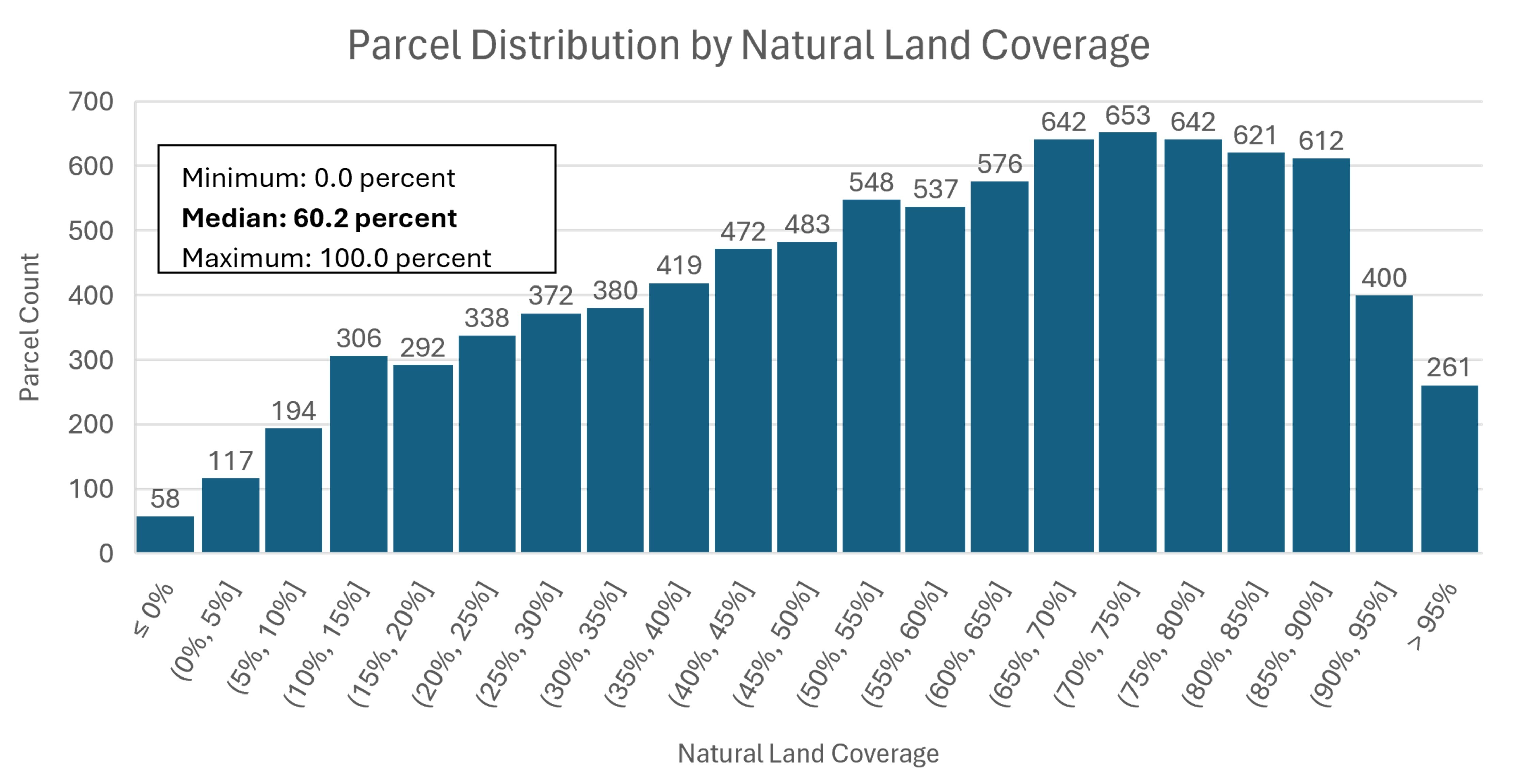
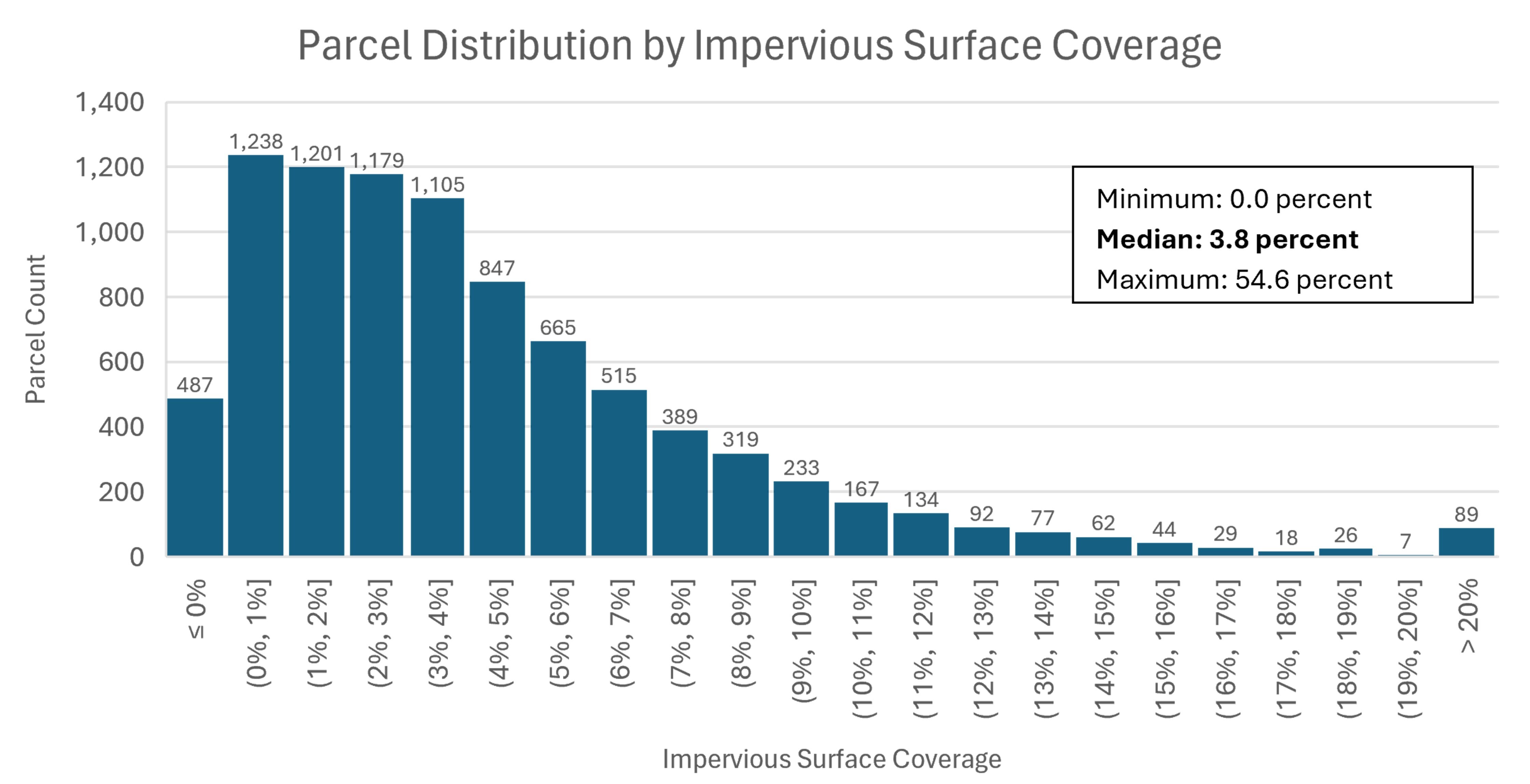
Results: This analysis yields 8,923 parcels across all four western Massachusetts counties, including 3,056 (34 percent) in Hampden County, 2,843 (32 percent) in Berkshire County, 2,176 (24 percent) in Hampshire County, and 848 (10 percent) in Franklin County. The largest number of parcels by municipality is in East Longmeadow (654), with at least 400 each in Pittsfield, Hadley, Agawam, and Easthampton. Notably, this search also identifies potential opportunities in some of the smaller towns in the area, including several hundred parcels in towns with populations under 5,000 such as Hatfield (207 parcels) and Hinsdale (150), and dozens in towns with populations under 2,000 such as Clarksburg (88), Northfield (69), Williamsburg (61), Russell (31), and Otis (29). Key characteristics of these 8,923 parcels are summarized below, showing that they range in size from one to over 200 acres, with the vast majority between one and two acres. The median parcel is 60 percent undeveloped natural land, 23 percent developed open space (e.g. lawns or crops), and 4 percent impervious surface, with the remainder comprised of existing structures or water.
Deeper Dive: We can narrow our search within specific cities or towns to identify neighborhoods where encouraging ADU development might be an impactful strategy. For example, we can focus on the town of Otis with 29 parcels that meet our initial criteria. These parcels are adjacent to an important corridor for the town, Route 8 (North and South Main Road), and this cluster of properties is positioned near the center of town with access to resources including the library, food pantry, post office, municipal offices, and park.
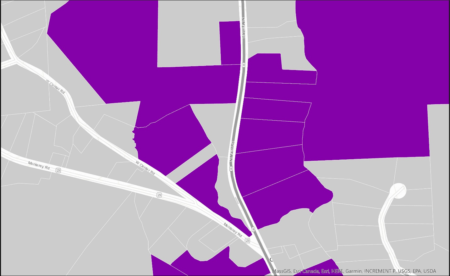
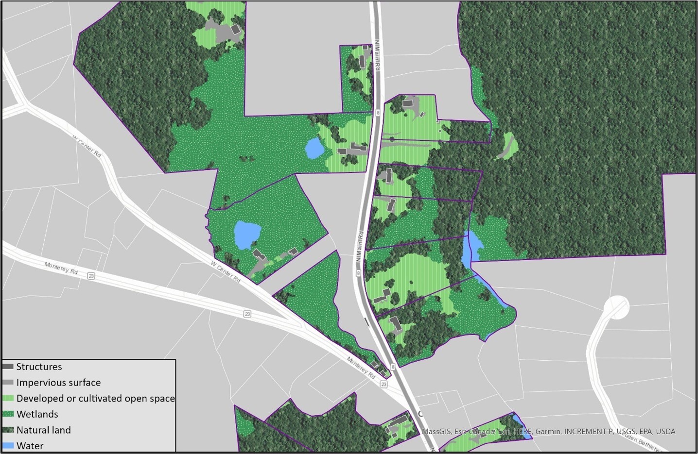
When we view existing structures together with land cover and land use data for these parcels, we can see areas of developed open space (light green) behind existing structures (dark gray) that could provide ample space for ADU development while avoiding forested areas (dark green) and wetlands (speckled green).
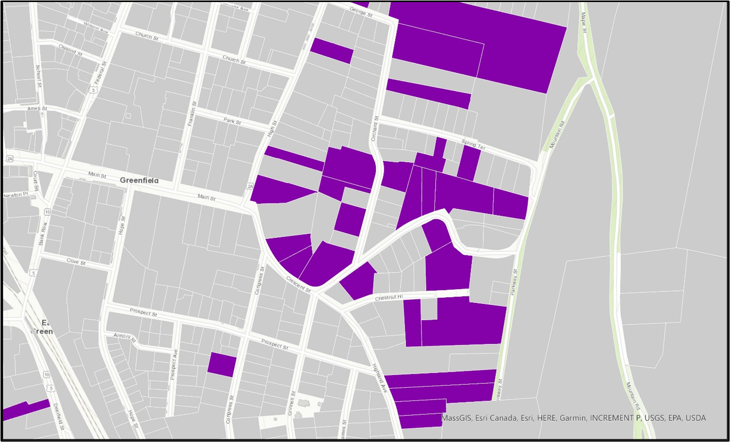
While it may seem obvious that there would be capacity for ADUs in rural communities where single-family homes are often on quite large lots, we can also locate significant opportunities in one of the region’s mid-sized cities. For example, we find 169 parcels in our initial search in Greenfield. Focusing on the Crossroads Cultural District along Main Street and its adjacent single-family neighborhoods, however, shows that our parameter only including parcels at least an acre in size may have excluded some potential sites.
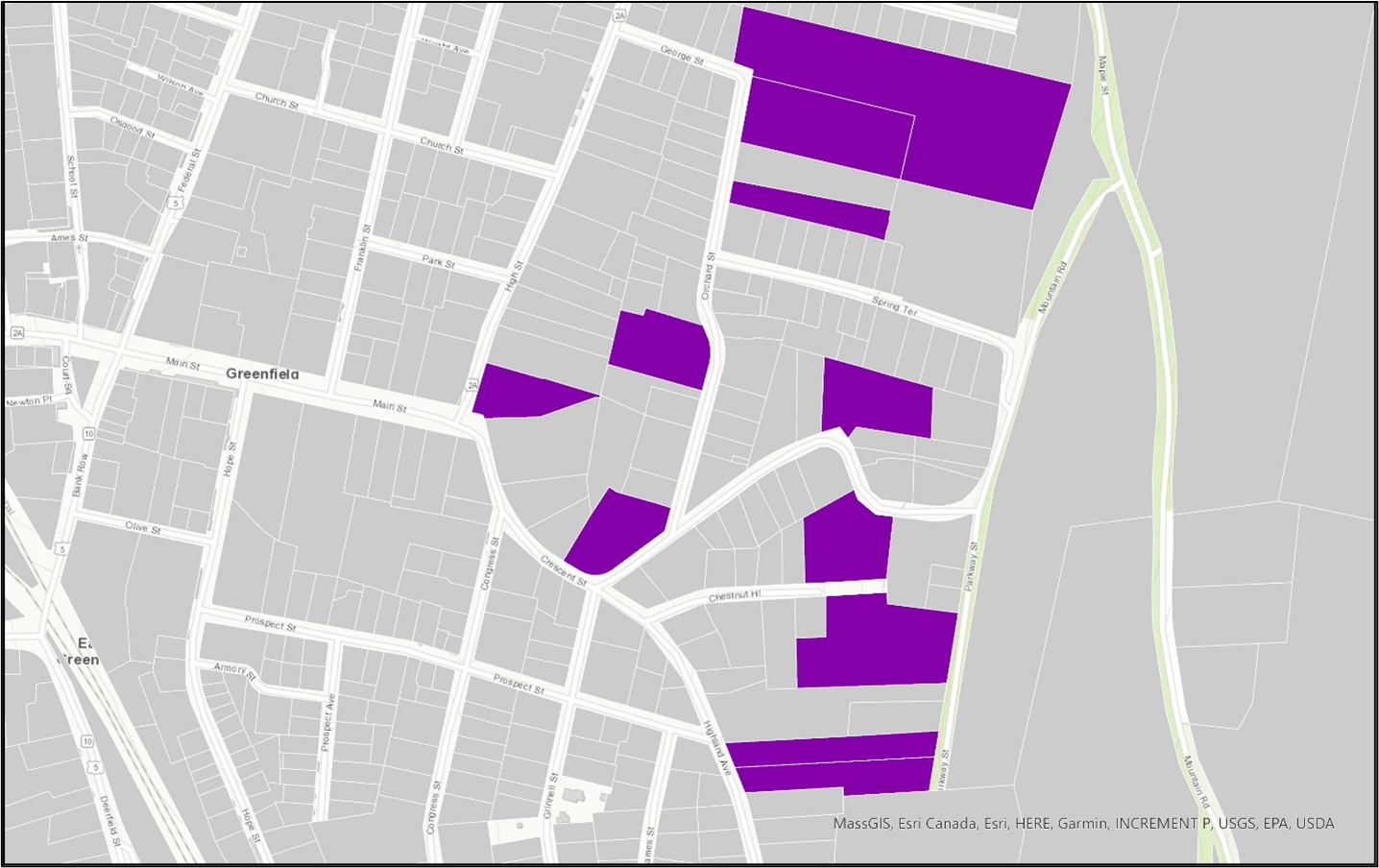
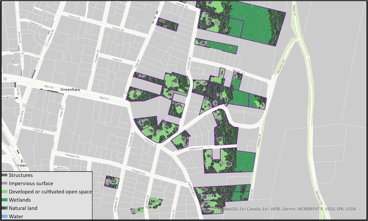
When we adjust our search to parcels at least half an acre in size, our count in Greenfield increases to 458, including more of the mid-size parcels near Main Street. We can then further explore the existing structures, land use, and land cover in this neighborhood to build our understanding of ADU development potential near this village center.
Summary: ADU construction has the potential to add much-needed homes to the housing supply across all types of communities. ADUs can fit into the existing neighborhood fabric, provide housing options at an appropriate size for households at all life stages, and create income-generating opportunities for homeowners. Identifying neighborhoods with high potential for ADU development can help municipal leaders and key stakeholders target policy proposals and new resources that facilitate production. Strategies in this type of district could include: tax incentives, tax abatements, and/or waived development fees for homeowners adding an ADU; pre-approved design plans that meet local zoning and building codes; and, streamlined permitting processes that simplify the development process while achieving local buy-in.
Scenario 3: Proactive investments to preserve affordable housing
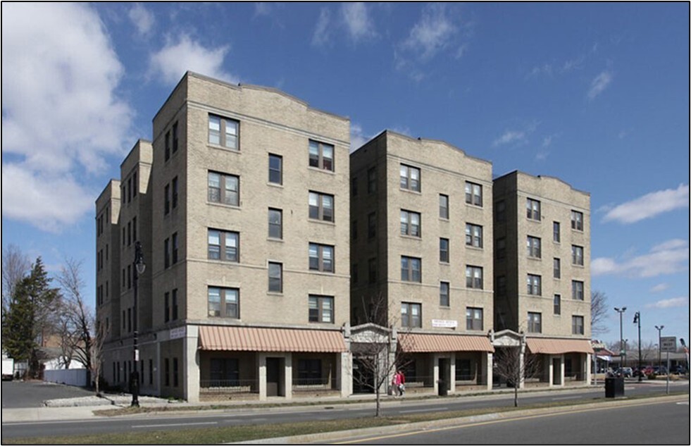
Project Typology: Investment in our existing affordable housing stock is crucial for maintaining and improving vital multifamily housing and can help spur revitalization of established neighborhoods. However, the purchase of low-rent, unsubsidized, unrestricted rental housing by investors or corporate interests can increase risks for unsustainable rent growth and resident displacement. By identifying areas that might be susceptible to speculative investment, municipalities, community organizations, affordable housing developers, and their partners can take steps to protect existing affordability and invest in these neighborhoods before for-profit development takes over. State, local, and private funds can be knitted together to support preservation projects, as in the example of the Van der Hayden Apartments in Springfield. With funding from MassHousing, federal and state Low-Income Housing Tax Credits, historic tax credits, the state Affordable Housing Trust Fund, the state Executive Office of Housing and Livable Communities, and the City of Springfield, a limited partnership group purchased this property with 45 homes in 2023 in the city’s centrally located Mason Square neighborhood. Funds will go toward renovations and improvements of the property built in 1914 and a 20-year federal Section 8 Housing Assistance Payment contract to keep all apartments affordable for households earning up to 50 percent of Area Median Income (AMI), including units affordable for those earning up to 30 percent of AMI.
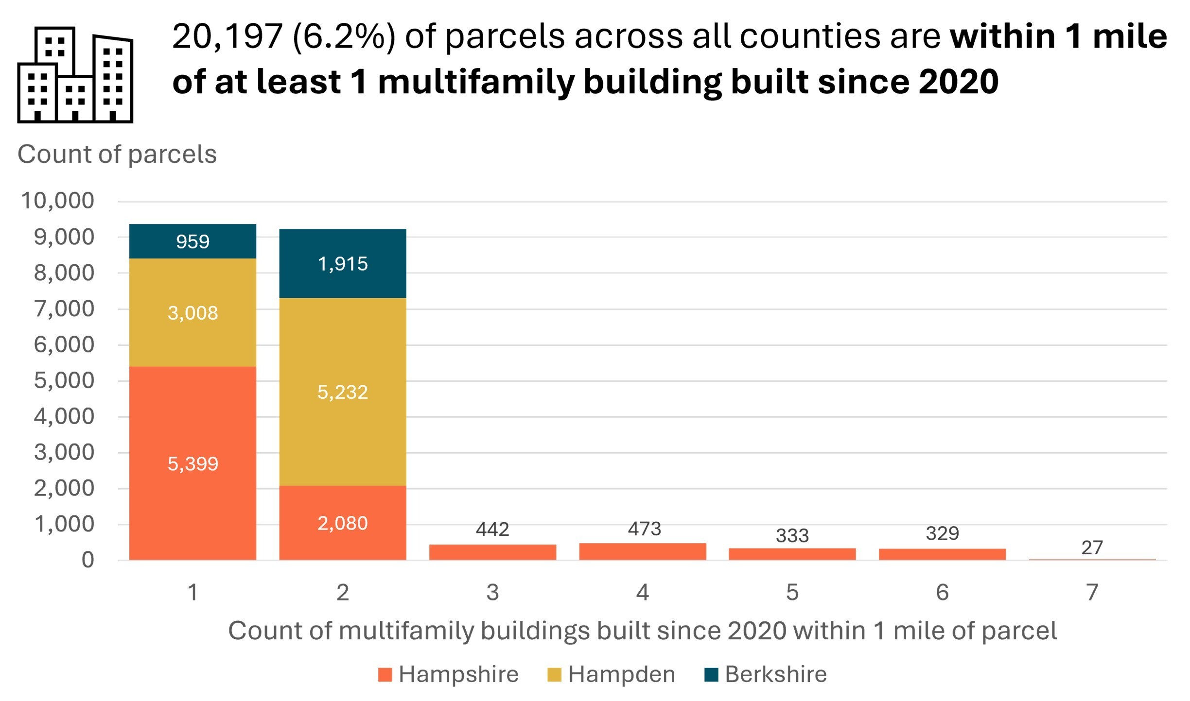
Analysis: We used available market data to identify neighborhoods beginning to experience changes that could pose affordability challenges for current renters. We relied on CoStar data for this analysis, which limited our view to Hampden and Hampshire counties. Within these areas, we looked for parcels with current multifamily uses (four units or more) located in ZIP codes where asking rent increased by at least four percent year over year, representing the 75th percentile of ZIP codes by change in asking rent. We also only included parcels within one mile of at least one multifamily development built since 2020 as an indicator that new housing investments are already occurring in the neighborhood.
Map Results
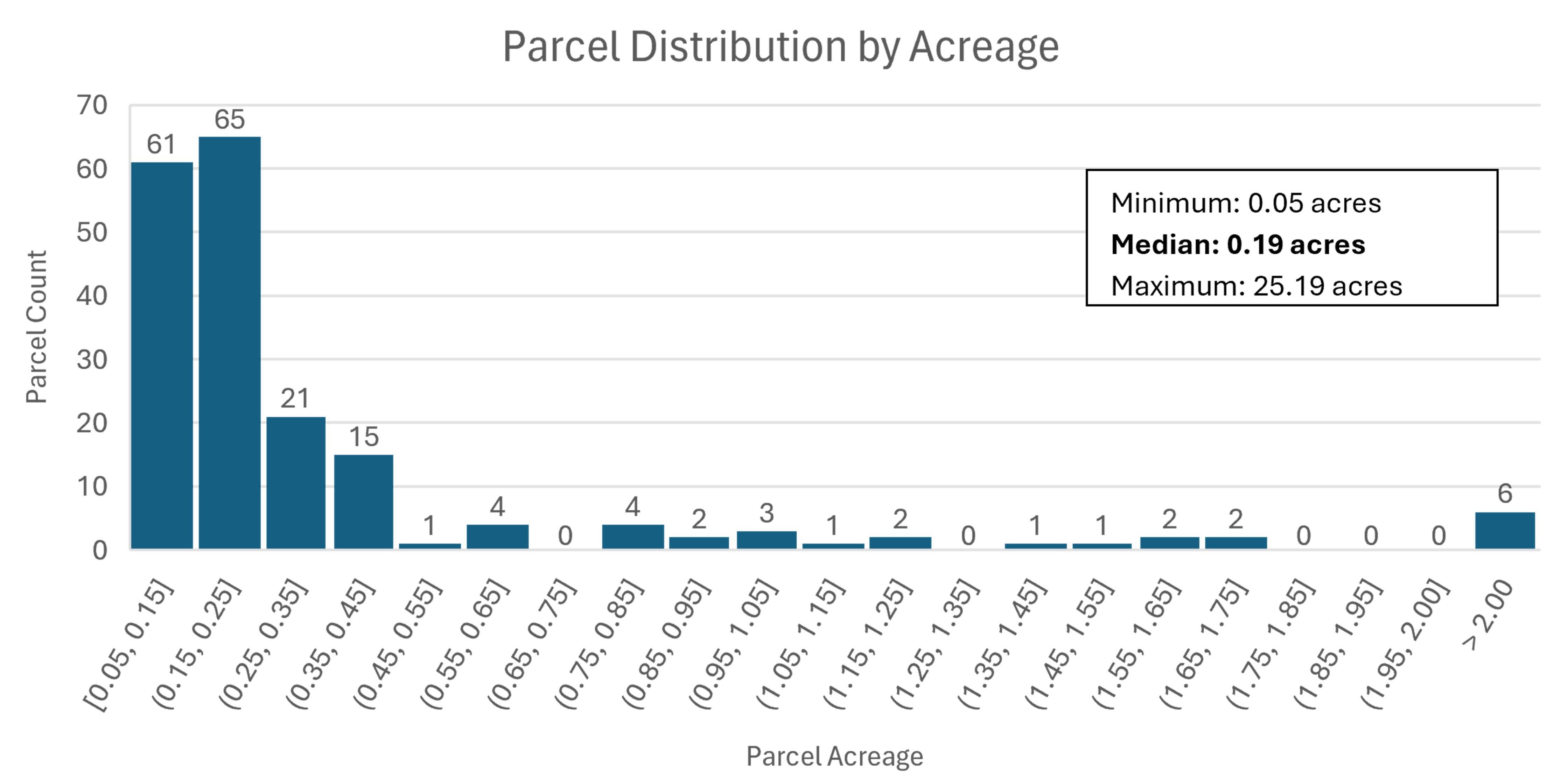
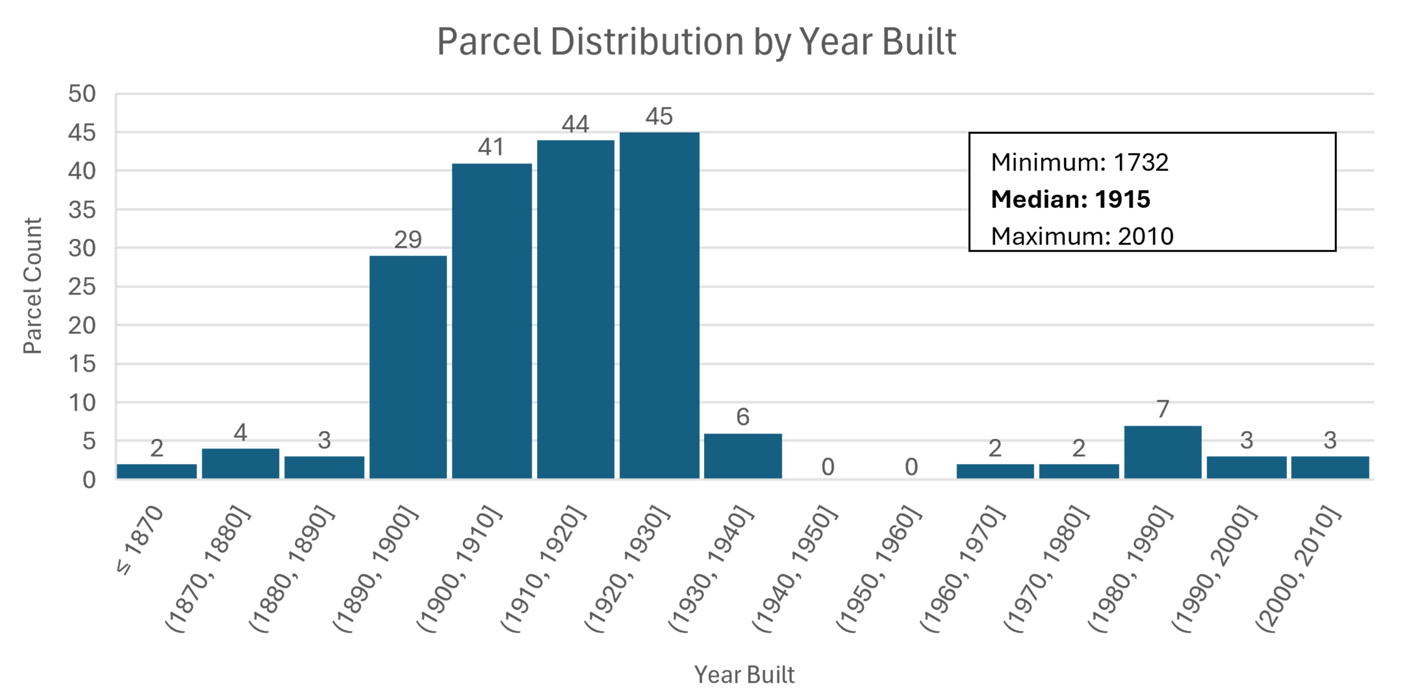
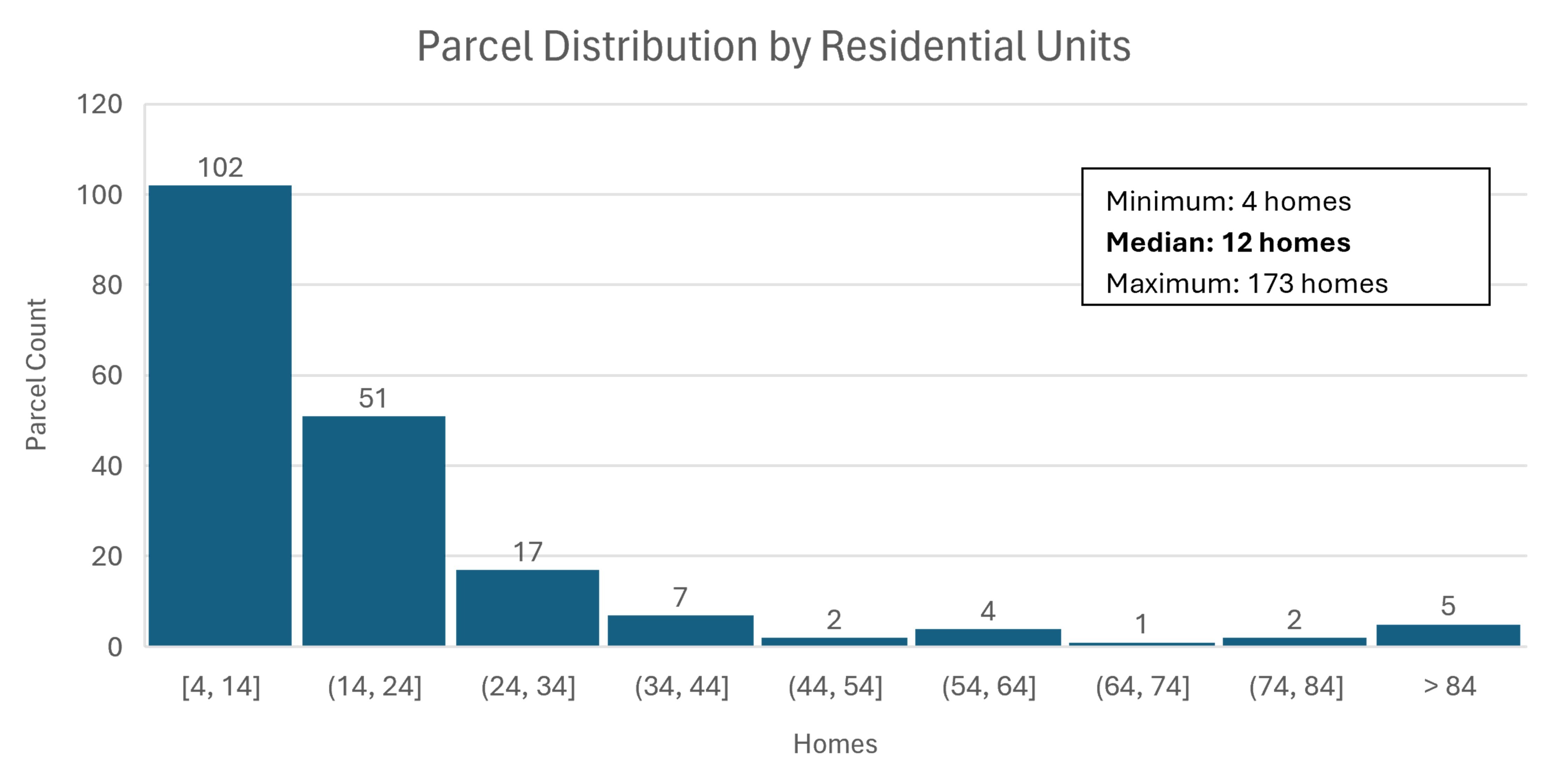
Results: This analysis yields 191 parcels, primarily in Hampden County (174 parcels) with an additional 17 parcels in Hampshire County. These are highly concentrated in Springfield (160 parcels, 83.8 percent) with smaller counts in West Springfield (14, 7.3 percent), Amherst (8, 4.2 percent), South Hadley (6, 3.1 percent) and Hadley (3, 1.6 percent). Key characteristics of these 191 parcels are summarized below, showing that they largely are under one-half of an acre, house older buildings with a median of 12 homes, and experienced year-over-year rent growth of up to 7.4 percent.
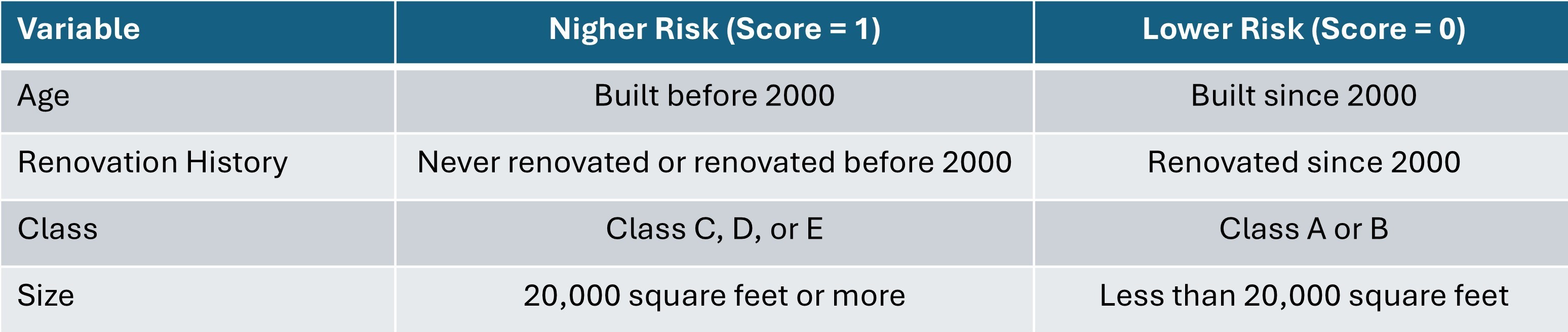
Deeper Dive: We can further focus our search by looking within neighborhoods of high concentrations of multifamily buildings showing some signs of distress as an indicator of speculation risk in the area. To identify these neighborhoods, we created risk scores for over 2,000 multifamily properties in western Massachusetts with data available through CoStar, assessing risk based on four criteria:
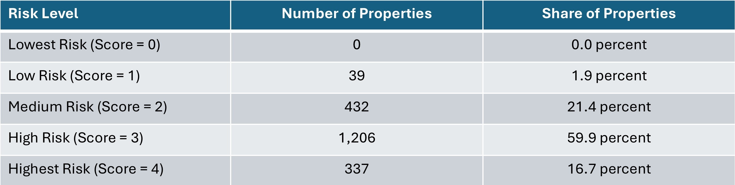
We then summed the component scores to create an overall score for each CoStar property with the following distribution:
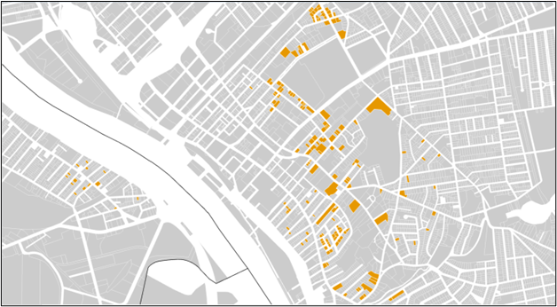
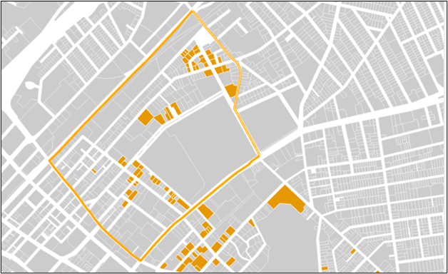
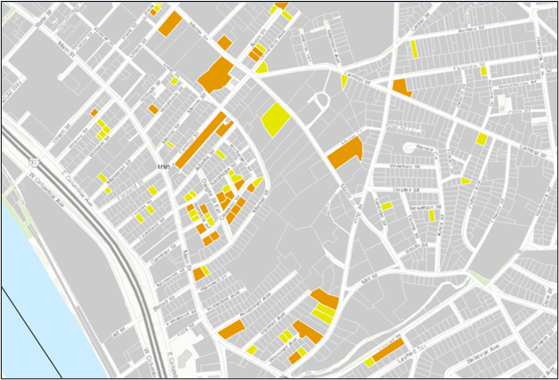
We then identified how many buildings of each risk type are located within each census tract. Tracts in Hampden and Hampshire Counties include between zero and 69 properties in the high or highest risk categories, with the median tract including three such properties. The 191 parcels identified in our initial search are all in tracts with between five and 59 high or highest risk properties, with their median tract including 36 properties. When we focus on the one tract with 59 such properties, we find 53 of our parcels within Springfield’s South End neighborhood, as shown below inside the orange tract border:
Of these 53 parcels, we identified 50 as having an institutional owner based on our analysis of the assessors ownership field. Exploring this data further, 12 of these properties are owned by corporate landlords with an office in Springfield, 24 are owned by corporate landlords located elsewhere in Massachusetts, and 14 are owned by out-of-state corporate landlords. Institutional owners can provide professional management and services for tenants; however, corporations may also maintain fewer ties to a local community and consider their full property portfolio, financial standing, and broader economic conditions when assessing rent increases for tenants. These properties therefore merit attention for potential future speculative sales that would impact existing residents. Monitoring these properties could enable intervention similar to the purchase of the Van der Hayden Apartments if a property is slated for sale.
In addition to keeping tabs on properties at risk of speculative sale, other properties in these neighborhoods can also be identified for targeted funding opportunities. The South End parcels highlighted in yellow below house 15 homes or fewer. If they also show signs of disrepair, as potentially indicated in this search, they could be candidates for support through the Neighborhood Stabilization Program.
Summary: Neighborhood investment can be accomplished without pricing out existing residents from experiencing the benefits of community growth. Monitoring areas of known recent rent increases coupled with new development can allow stakeholders to identify properties at risk of speculative purchase or approaching disrepair. Interventions to purchase such properties take significant coordination and often involve multiple partners, so anticipating potential opportunities allows community-minded groups time to assemble resources and deploy policies to compete with for-profit developers.
Scenario 4: Diverse strategies and partnerships in Gateway Cities
Project Typology: The western Massachusetts Gateway Cities of Chicopee, Holyoke, Pittsfield, Springfield, and Westfield are vibrant and diverse communities home to over 40 percent of the region’s residents. The unique housing challenges and opportunities of these communities are outlined in detail in the 2024 Gateway Cities Housing Monitor prepared by the MassINC Policy Center. Across the 26 Gateway Cities in the state, the Monitor highlights the need to increase housing supply to keep pace with household growth. While most of the 26, including Chicopee, Springfield, and Westfield, added somewhat to their housing stock between 2012 and 2022 at a pace near or under their household growth rate, two western Massachusetts cities, Holyoke and Pittsfield, faced losses of both homes and population over that period. The Monitor also notes that the financial feasibility of new construction is difficult to achieve in western Massachusetts – the region’s five Gateway Cities have among the six highest “financial gaps” of all 26, as each new rental unit costs nearly $300,000 more to build and operate than is expected in capitalized rent.
With such a high barrier to new construction, preserving the Gateway Cities’ existing housing stock is paramount. Through programs like Way Finders’ City of Homes in Springfield and Westside Legends in Pittsfield, organizations are working across the region to buy, renovate, and resell vacant and disinvested properties to prevent speculative purchase, demolition, and neighborhood blight. Identifying additional redevelopment opportunities in neighborhoods in high need of reinvestment can buttress revitalization efforts that support existing residents. Such opportunities on public land or in partnership with nonprofit partners outside the development space can help to both address Gateway Cities’ critical housing needs and strengthen these vital communities.
Analysis: The Gateway Cities Housing Monitor notes the “other vacant” category of properties in the American Community Survey (ACS) – which captures vacant units other than those listed for rent or sale, rented or sold but not yet occupied, used for seasonal, recreational, or occasional purposes, or for migrant workers – can be used to identify areas of potential blight in need of investment. According to the report, “neighborhoods merit attention when this measure exceeds 8 percent.” In addition, the authors note that “high-churn” neighborhoods where residents move frequently (defined as more than 20 percent of residents moving in the past 12 months) can experience more residential instability with weaker community bonds.
To explore these areas, we identified parcels in Gateway City census tracts with an “other” vacancy rate over eight percent and over 20 percent of residents moving in the past year. As programs like City of Homes and Westside Legends target small properties for renovation and resale back to the community, we focused our initial search on parcels with single-, two-, or three-family homes.
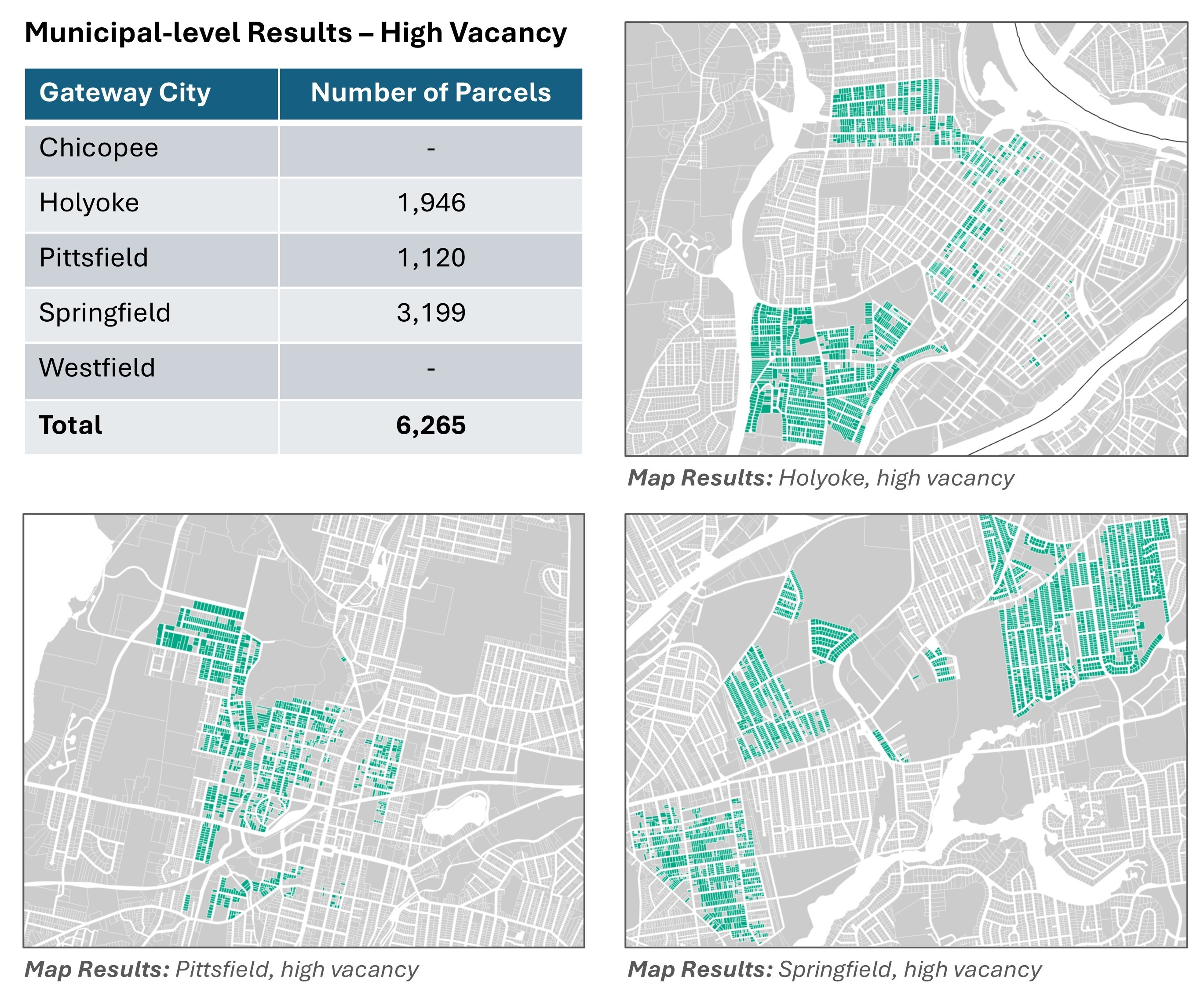
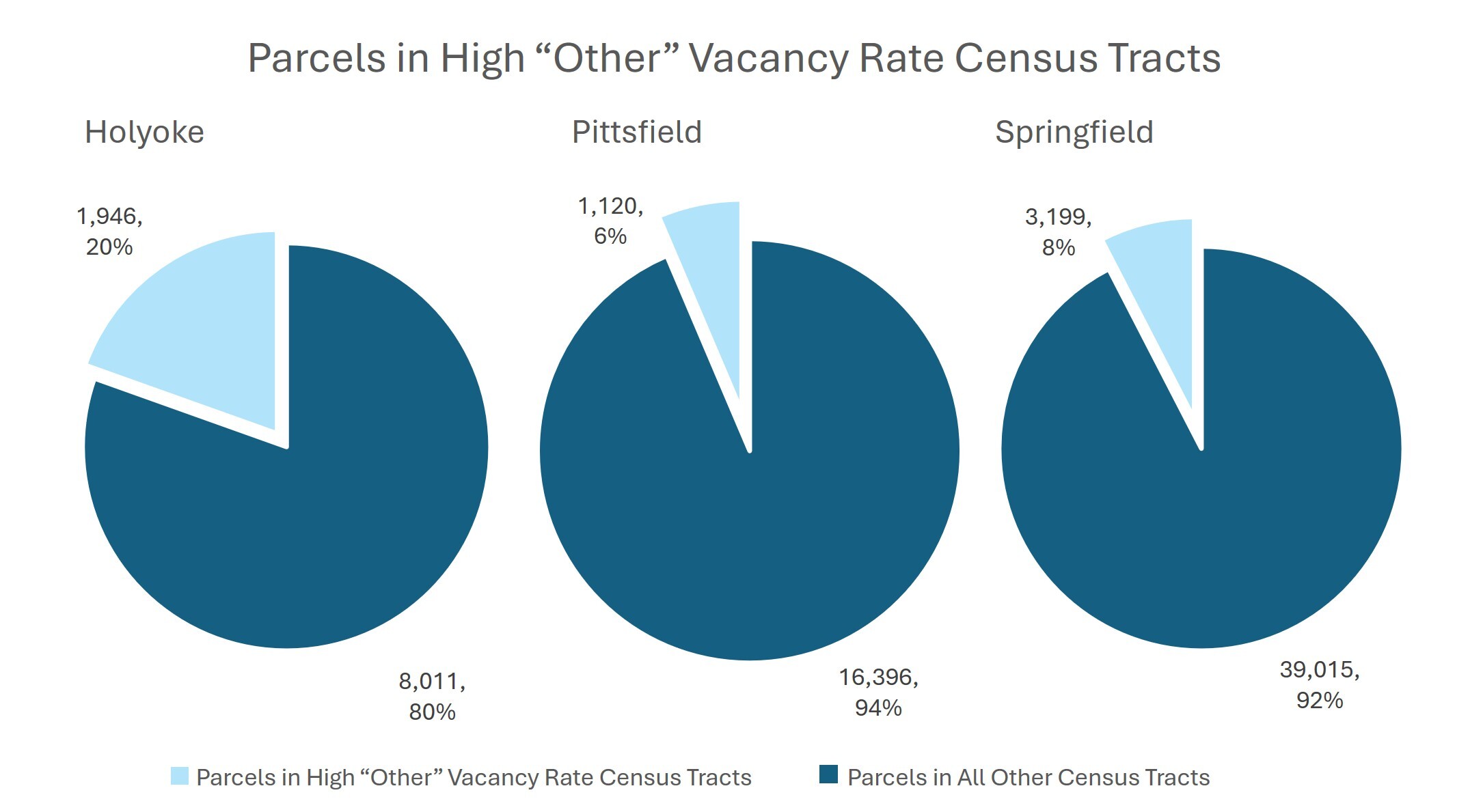
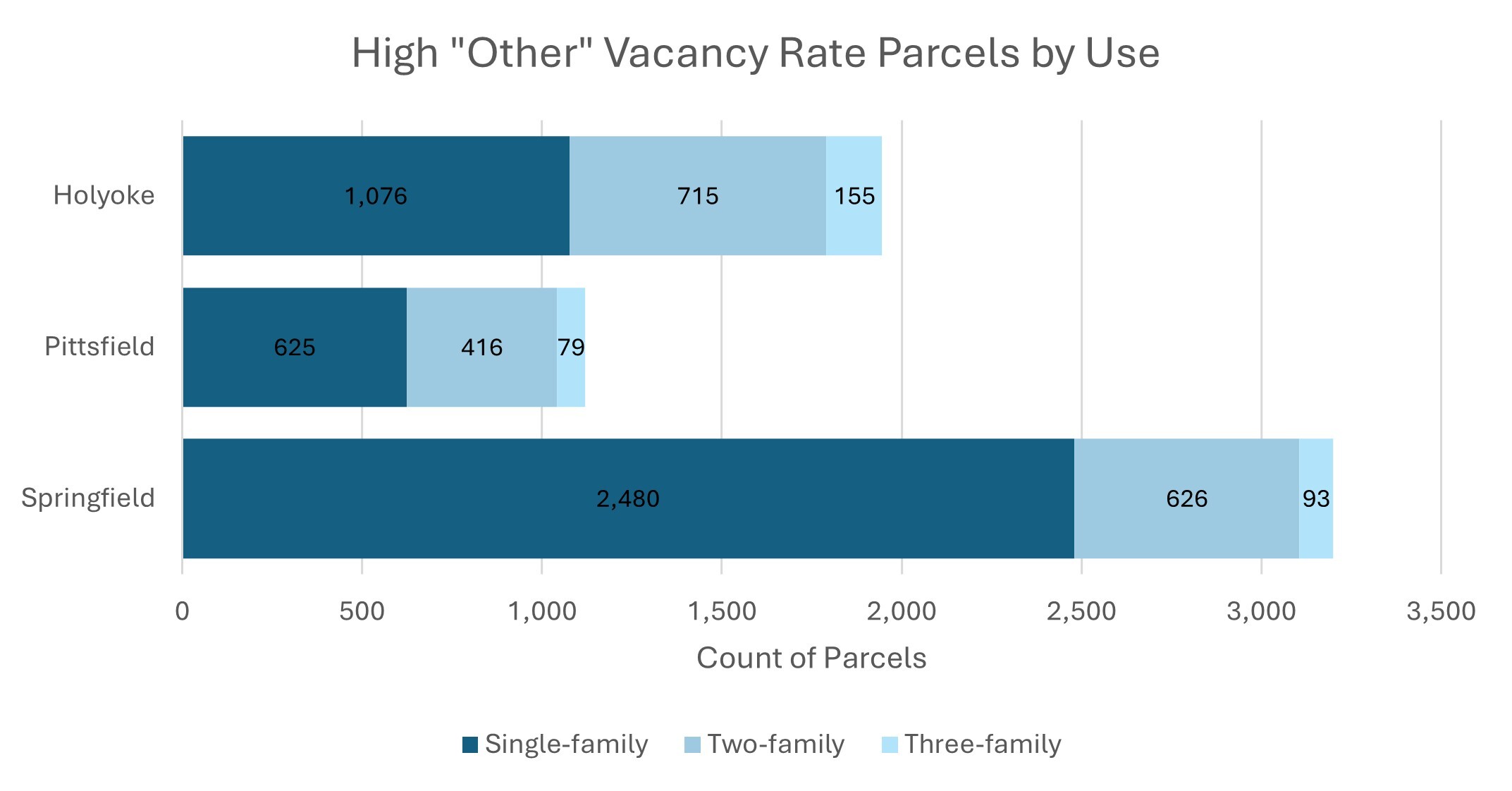
Results: This analysis identified over 6,000 parcels in high “other” vacancy rate tracts in Gateway Cities, representing 6 percent of all parcels in these cities. These parcels are located in three communities – Holyoke, Pittsfield, and Springfield – with the largest number of parcels in Springfield and the largest share of the city’s total parcels in Holyoke. The majority of parcels contain single-family homes, with smaller shares housing two- and three-family homes.
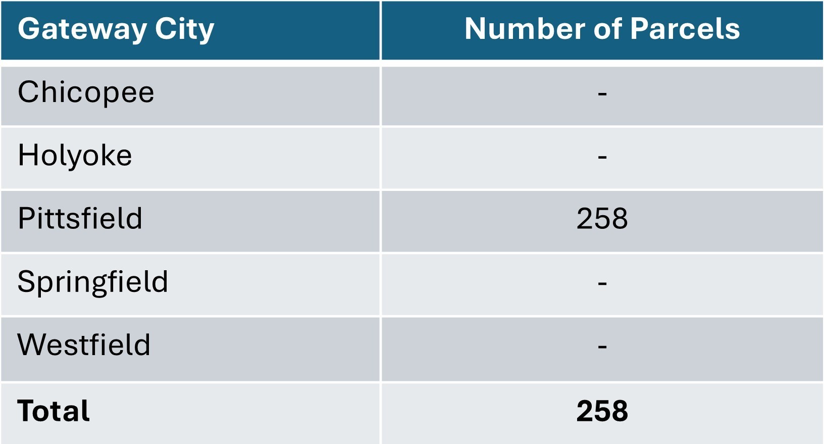
When we narrow these tracts to those that are also “high churn,” with more than 20 percent of residents moving in the past 12 months, we find 258 parcels all located in Pittsfield and shown in yellow below.
Municipal-level Results – High Vacancy, High Churn
Map Results
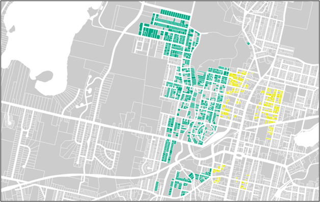
Our “high vacancy, high churn” results fall into the Westside neighborhood of Pittsfield – where Westside Legends already successfully operates their program. The data confirms the high level of need in this neighborhood, but there’s also more we can learn from this exploration.
Deeper Dive: The highly targeted, homeowner-level interventions enabled by programs like City of Homes and Westside Legends often rely on the emergence of unique opportunities to purchase properties as they become available through direct sale, city-issued requests for proposals (RFP), or Special Attorney Receivership. Identifying neighborhoods in high need for these types of programs can help focus resources not only for these valuable investments but for other types of housing investments as well.
Publicly owned land offers a valuable resource for potential development or redevelopment of housing. It also often relies on RFP or word-of-mouth opportunities arising, but by homing in on areas in our Gateway Cities we know would benefit from investment, partners can be better prepared to respond to these opportunities as they become available and to actively seek them out. Given the significant financial feasibility gap of new construction in the area’s Gateway Cities, collaborating with public agencies to acquire vacant or underutilized land can lower development or redevelopment costs and improve project feasibility.
If we look within the same high need neighborhoods in Pittsfield, we also find 151 parcels identified as “Tax-exempt, charitable, or institutional” in their assessors use description, shown in pink below. These encompass a wide range of uses including federal, state, and local government buildings, schools, hospitals, religious institutions, nonprofit organizations, vacant land, and open space. Digging into additional details of these use descriptions, we find that within this area of Pittsfield, these parcels are concentrated among charitable services or organizations (31), religious organizations (27), and municipal land – both improved (26) and vacant (24).
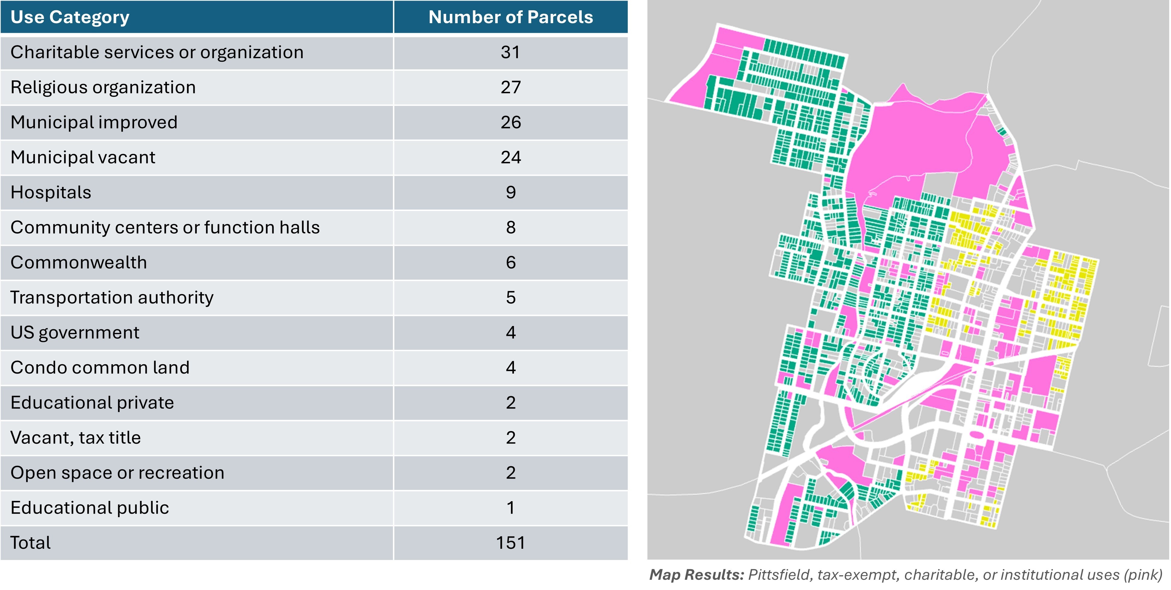
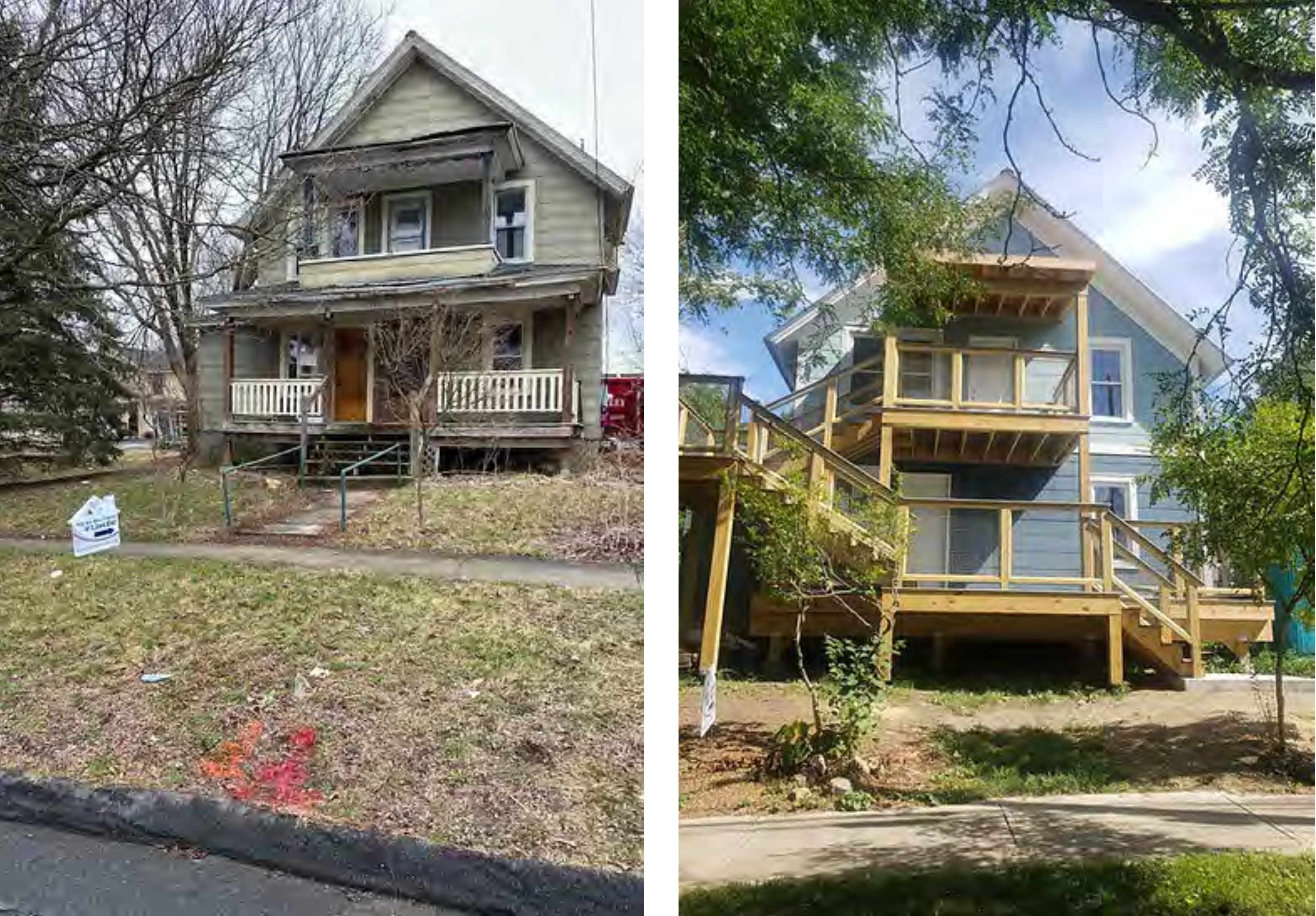
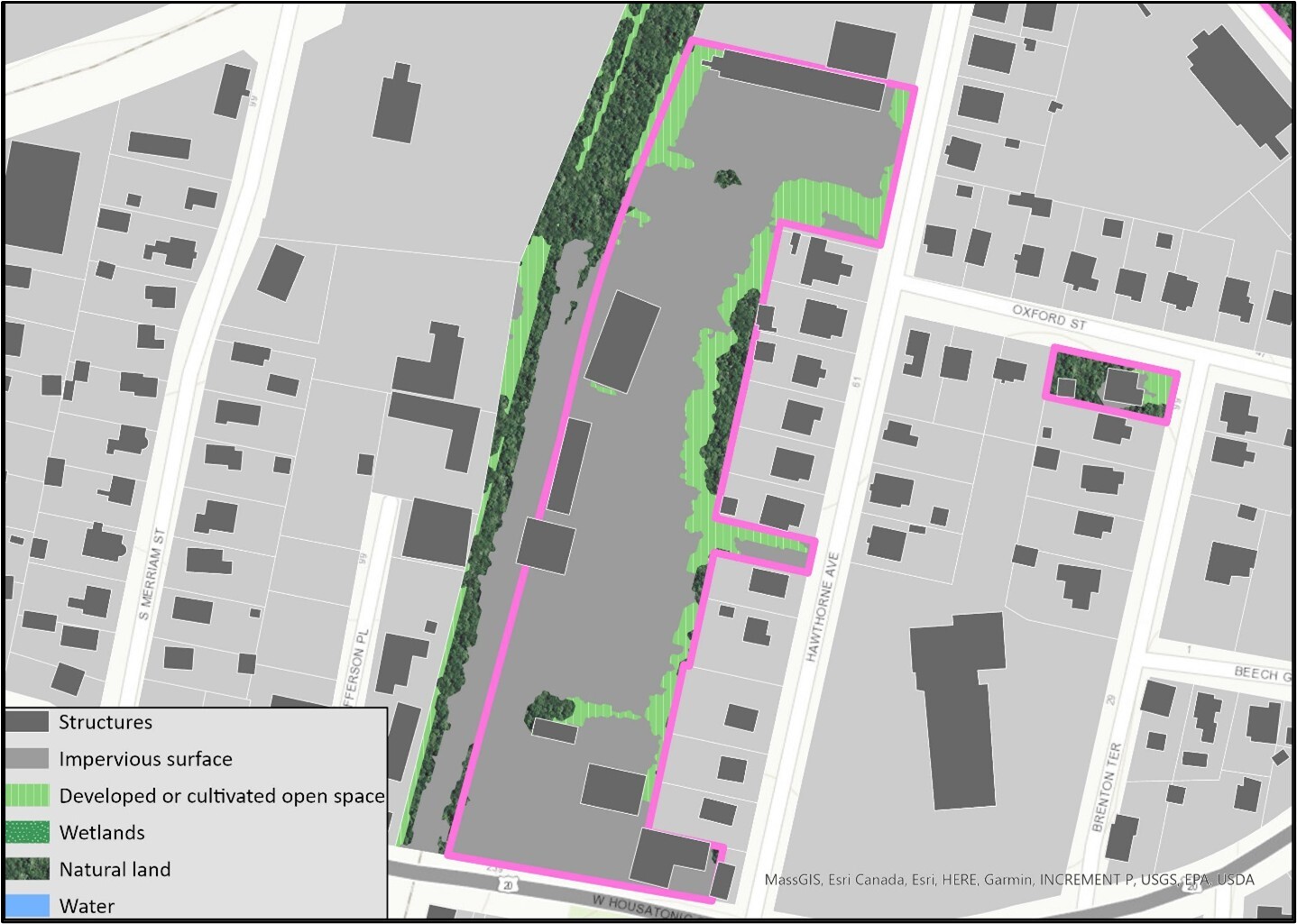
Filtering to these different use types on the map allows us to explore potential opportunities visually. Among the 26 parcels listed as “municipal improved” is the large site shown below outlined in pink, on Hawthorne Avenue in Pittsfield. This parcel owned by the City of Pittsfield is 6.3 mostly paved acres and contains multiple structures. Our land use/land cover data shows that impervious surface covers 70 percent of the site, structures constitute 12 percent, and the rest is developed open space. The site is not in a historic area, is within one quarter-mile of two RTA bus stops, and is near a brownfields site. There are some industrial buildings nearby, though the area is largely residential, with two- and three-family homes adjacent to the site and the Park Place Condominiums across the street. A Google search reveals this site is the city’s Public Buildings Maintenance facility – an essential city function, but perhaps one that could be relocated outside of this residential neighborhood if this large parcel could be utilized instead for community housing.
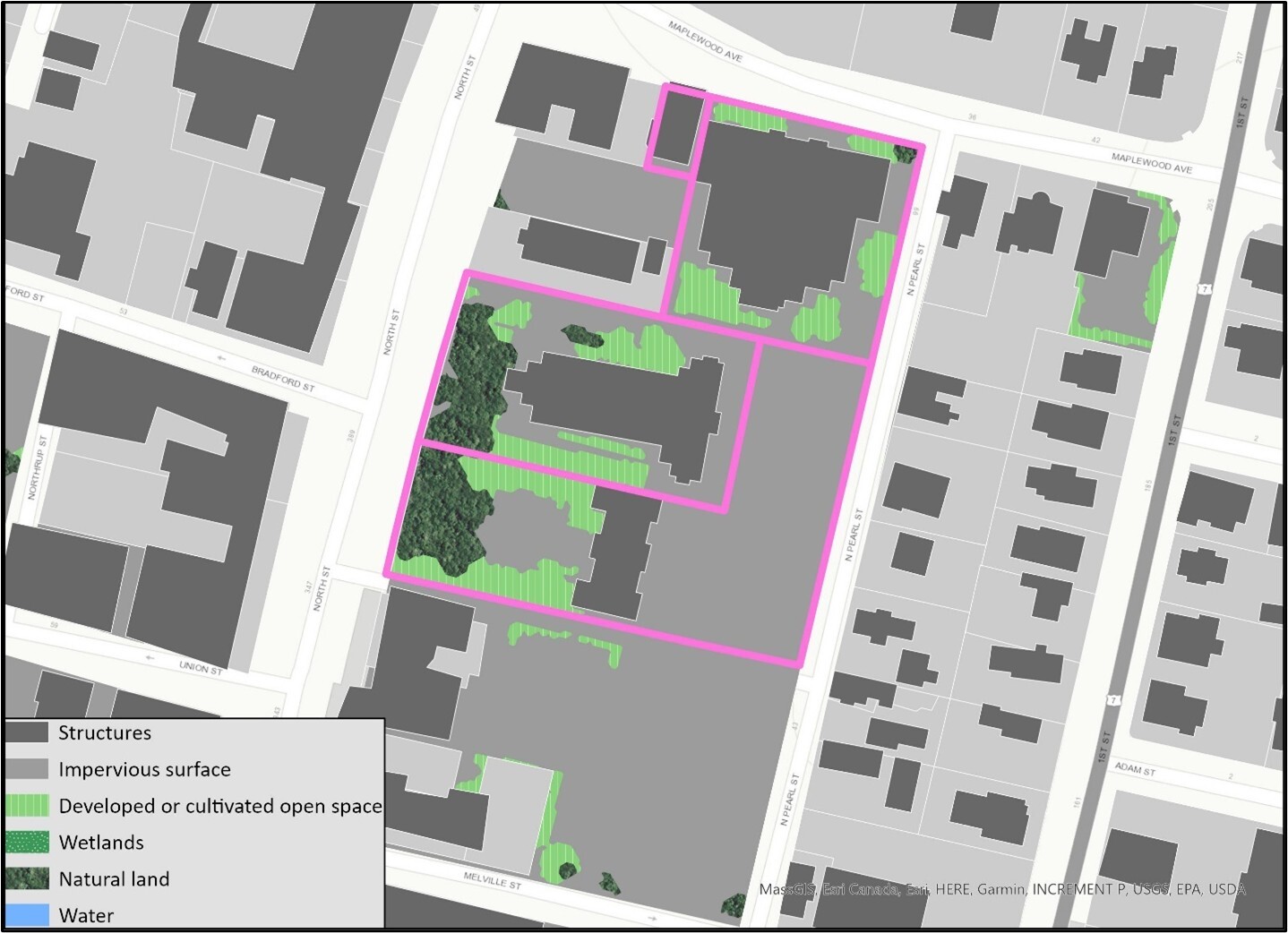
Exploring the neighborhood parcels listed with uses related to religious organizations, we find the four adjacent parcels shown below. The parcel with the large building at the corner of Pittsfield’s Maplewood Avenue and North Pearl Street is the former St. Joseph Central High School, currently vacant and listed for sale since 2018. This one-acre site contains the over 40,000 square foot school building and is owned by the St. Joseph’s Educational Association with a deed restriction from the Roman Catholic Bishop of Springfield. The other two large parcels are the active St. Joseph’s Church on 1.1 acres and a second building owned by the St. Joseph’s Educational Association on 1.6 acres including a large parking lot. These buildings face North Street, an arts and cultural district. The fourth parcel, under 0.10 acres on Maplewood Avenue, is owned and occupied by Berkshire Community Action. As with all potential sites highlighted here, these sites require due diligence and a deeper understanding of their use and utility, but the combination of a vacant building adjacent to religious sites with potential excess land and interest in partnership, a community resource center, a strong downtown area, and a residential neighborhood present an opportunity for reinvestment and redevelopment that could be explored.
Conclusion
As in the state as a whole, western Massachusetts is in dire need of more housing options to support established residents and encourage community growth. Identifying opportunities for new housing development, redevelopment, and reinvestment that fits the scale, character, needs, and resources of the region is a necessary first step. Through this engagement, Way Finders and CHD have demonstrated how the combination of local expertise and robust data can begin to find these opportunities. We have used the dataset we assembled to answer research questions around four distinct development types – infill development on commercial and industrial sites, accessory dwelling units in a variety of community settings, targeted purchases to protect existing affordable multifamily homes and prevent speculation, and reinvestment in neighborhoods in need through partnership with community stakeholders. Moving forward, this data can be used as a platform for additional exploration that aligns with programs, policies, and strategies Way Finders and its partners are pursuing as cornerstone regional organizations committed to community-driven development.
Land Use Analyses
Current Land Use
Site Composition
Site Considerations
Access to Infrastructure
Neighborhood Development
Appendix
Appendix A: Field Report - Housing Opportunities and Institutional Investment Risk in Western MA (PDF)
Appendix B: Data Dictionary (PDF)